
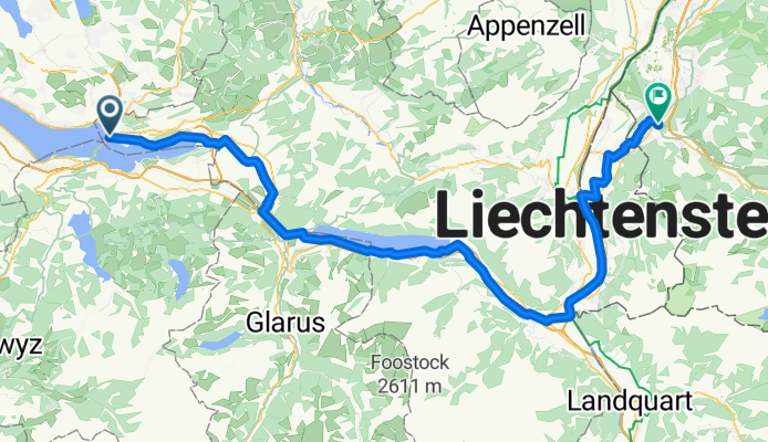
Challenge Tour: Rapperswil - Feldkirch
A cycling route starting in Rapperswil, Canton of St. Gallen, Switzerland.
Overview
About this route
Challenge Tour: Rapperswil -> Feldkirch
- -:--
- Duration
- 95.9 km
- Distance
- 138 m
- Ascent
- 88 m
- Descent
- ---
- Avg. speed
- ---
- Max. altitude

Route quality
Waytypes & surfaces along the route
Waytypes
Quiet road
33.9 km
(35 %)
Path
19.1 km
(20 %)
Surfaces
Paved
81.6 km
(85 %)
Unpaved
8.2 km
(9 %)
Asphalt
77 km
(80 %)
Gravel
7.1 km
(7 %)
Continue with Bikemap
Use, edit, or download this cycling route
You would like to ride Challenge Tour: Rapperswil - Feldkirch or customize it for your own trip? Here is what you can do with this Bikemap route:
Free features
- Save this route as favorite or in collections
- Copy & plan your own version of this route
- Split it into stages to create a multi-day tour
- Sync your route with Garmin or Wahoo
Premium features
Free trial for 3 days, or one-time payment. More about Bikemap Premium.
- Navigate this route on iOS & Android
- Export a GPX / KML file of this route
- Create your custom printout (try it for free)
- Download this route for offline navigation
Discover more Premium features.
Get Bikemap PremiumFrom our community
Other popular routes starting in Rapperswil
 Walensee-Rheintal-Appenzell
- Distance
- 174.7 km
- Ascent
- 1,275 m
- Descent
- 1,270 m
- Location
- Rapperswil, Canton of St. Gallen, Switzerland
 Day 6: Turbental
- Distance
- 83 km
- Ascent
- 0 m
- Descent
- 0 m
- Location
- Rapperswil, Canton of St. Gallen, Switzerland
 Kempraten-Atzmännig-Hiltisberg-Kempraten
- Distance
- 44.6 km
- Ascent
- 649 m
- Descent
- 643 m
- Location
- Rapperswil, Canton of St. Gallen, Switzerland
 Rund um die Rigi
- Distance
- 119.8 km
- Ascent
- 1,070 m
- Descent
- 1,067 m
- Location
- Rapperswil, Canton of St. Gallen, Switzerland
 Rapperswil-Sass da Grüm
- Distance
- 270.6 km
- Ascent
- 2,119 m
- Descent
- 2,064 m
- Location
- Rapperswil, Canton of St. Gallen, Switzerland
 Sattelegg - Ibergeregg - Zugersee
- Distance
- 117.9 km
- Ascent
- 1,857 m
- Descent
- 1,858 m
- Location
- Rapperswil, Canton of St. Gallen, Switzerland
 Schönbodenstrasse 56, Rapperswil-Jona nach Schönbodenstrasse 56, Rapperswil-Jona
- Distance
- 38.5 km
- Ascent
- 293 m
- Descent
- 293 m
- Location
- Rapperswil, Canton of St. Gallen, Switzerland
 JN 4.2 Vierwaldstädter See
- Distance
- 65.3 km
- Ascent
- 789 m
- Descent
- 776 m
- Location
- Rapperswil, Canton of St. Gallen, Switzerland
Open it in the app