

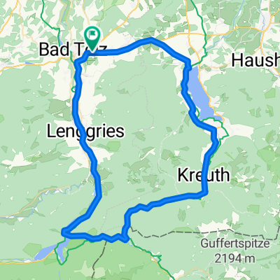
Bad Tölz - Reichersbeuern
A cycling route starting in Gaißach, Bavaria, Germany.
Overview
About this route
Gravel, forest paths, gentle climbs
- -:--
- Duration
- 18 km
- Distance
- 190 m
- Ascent
- 189 m
- Descent
- ---
- Avg. speed
- ---
- Max. altitude
Route quality
Waytypes & surfaces along the route
Waytypes
Track
13 km
(72 %)
Road
3.4 km
(19 %)
Surfaces
Paved
6.8 km
(38 %)
Unpaved
11 km
(61 %)
Asphalt
6.8 km
(38 %)
Gravel
5.6 km
(31 %)
Continue with Bikemap
Use, edit, or download this cycling route
You would like to ride Bad Tölz - Reichersbeuern or customize it for your own trip? Here is what you can do with this Bikemap route:
Free features
- Save this route as favorite or in collections
- Copy & plan your own version of this route
- Sync your route with Garmin or Wahoo
Premium features
Free trial for 3 days, or one-time payment. More about Bikemap Premium.
- Navigate this route on iOS & Android
- Export a GPX / KML file of this route
- Create your custom printout (try it for free)
- Download this route for offline navigation
Discover more Premium features.
Get Bikemap PremiumFrom our community
Other popular routes starting in Gaißach
 Gaißach-Schaftlach
- Distance
- 28.4 km
- Ascent
- 162 m
- Descent
- 162 m
- Location
- Gaißach, Bavaria, Germany
 Aueralm
- Distance
- 34 km
- Ascent
- 779 m
- Descent
- 779 m
- Location
- Gaißach, Bavaria, Germany
 Blombergrunde Nordhang
- Distance
- 26.9 km
- Ascent
- 694 m
- Descent
- 697 m
- Location
- Gaißach, Bavaria, Germany
 Tölz - Wiessee - Sylvenstein
- Distance
- 71.1 km
- Ascent
- 455 m
- Descent
- 454 m
- Location
- Gaißach, Bavaria, Germany
 Von Bad Tölz zur Aueralm
- Distance
- 41.6 km
- Ascent
- 911 m
- Descent
- 910 m
- Location
- Gaißach, Bavaria, Germany
 Tölz-Kochel-Jachenau-Tölz
- Distance
- 94.1 km
- Ascent
- 518 m
- Descent
- 518 m
- Location
- Gaißach, Bavaria, Germany
 TA 2011 Variante 1
- Distance
- 288.5 km
- Ascent
- 6,668 m
- Descent
- 6,050 m
- Location
- Gaißach, Bavaria, Germany
 Leipzig Final ?
- Distance
- 607.4 km
- Ascent
- 709 m
- Descent
- 1,335 m
- Location
- Gaißach, Bavaria, Germany
Open it in the app