

Palo,CostaTeguise,Tahiche,Mala,Palo
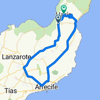
A cycling route starting in Haría, Canary Islands, Spain.
Overview
About this route
43 km 310 hm
- -:--
- Duration
- 43.1 km
- Distance
- 366 m
- Ascent
- 366 m
- Descent
- ---
- Avg. speed
- ---
- Max. altitude
Route highlights
Points of interest along the route
Accommodation after 43.1 km
Continue with Bikemap
Use, edit, or download this cycling route
You would like to ride Palo,CostaTeguise,Tahiche,Mala,Palo or customize it for your own trip? Here is what you can do with this Bikemap route:
Free features
- Save this route as favorite or in collections
- Copy & plan your own version of this route
- Sync your route with Garmin or Wahoo
Premium features
Free trial for 3 days, or one-time payment. More about Bikemap Premium.
- Navigate this route on iOS & Android
- Export a GPX / KML file of this route
- Create your custom printout (try it for free)
- Download this route for offline navigation
Discover more Premium features.
Get Bikemap PremiumFrom our community
Other popular routes starting in Haría
 MTB-Tour vom Mirador del Rio zur Costa Calero
- Distance
- 59 km
- Ascent
- 853 m
- Descent
- 1,272 m
- Location
- Haría, Canary Islands, Spain
 80km from Costa Tequise
- Distance
- 81.5 km
- Ascent
- 912 m
- Descent
- 1,206 m
- Location
- Haría, Canary Islands, Spain
 Calle Brezo de Mar, 7, Teguise nach Calle Brezo de Mar, 1, Teguise
- Distance
- 15.3 km
- Ascent
- 786 m
- Descent
- 789 m
- Location
- Haría, Canary Islands, Spain
 Lanzarote 3
- Distance
- 113.2 km
- Ascent
- 1,415 m
- Descent
- 1,421 m
- Location
- Haría, Canary Islands, Spain
 Palo,CostaTeguise,Tahiche,Mala,Palo
- Distance
- 43.1 km
- Ascent
- 366 m
- Descent
- 366 m
- Location
- Haría, Canary Islands, Spain
 Tabayesco to Mirador del Río and back
- Distance
- 32.2 km
- Ascent
- 636 m
- Descent
- 636 m
- Location
- Haría, Canary Islands, Spain
 Lanzarote 2
- Distance
- 91.9 km
- Ascent
- 1,127 m
- Descent
- 1,127 m
- Location
- Haría, Canary Islands, Spain
 Erkundungsritt Lanzarote
- Distance
- 119.5 km
- Ascent
- 1,372 m
- Descent
- 1,371 m
- Location
- Haría, Canary Islands, Spain
Open it in the app