

25.10.2015 Über Luftschiff,,Kirchenradweg Brauverein Jenaprisnitz .gpx
A cycling route starting in Neuengönna, Thuringia, Germany.
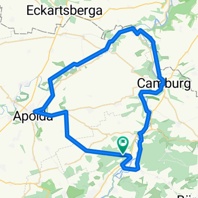
Overview
About this route
Besuch der Brauhauses in Jenaprißnitz mit Bierverkostung
- -:--
- Duration
- 35.8 km
- Distance
- 346 m
- Ascent
- 354 m
- Descent
- ---
- Avg. speed
- ---
- Max. altitude

Route quality
Waytypes & surfaces along the route
Waytypes
Quiet road
14.5 km
(41 %)
Track
6.8 km
(19 %)
Surfaces
Paved
25.8 km
(72 %)
Unpaved
5 km
(14 %)
Asphalt
24.5 km
(69 %)
Gravel
5 km
(14 %)
Continue with Bikemap
Use, edit, or download this cycling route
You would like to ride 25.10.2015 Über Luftschiff,,Kirchenradweg Brauverein Jenaprisnitz .gpx or customize it for your own trip? Here is what you can do with this Bikemap route:
Free features
- Save this route as favorite or in collections
- Copy & plan your own version of this route
- Sync your route with Garmin or Wahoo
Premium features
Free trial for 3 days, or one-time payment. More about Bikemap Premium.
- Navigate this route on iOS & Android
- Export a GPX / KML file of this route
- Create your custom printout (try it for free)
- Download this route for offline navigation
Discover more Premium features.
Get Bikemap PremiumFrom our community
Other popular routes starting in Neuengönna
 Saale-Ilm-Saale-Tour
- Distance
- 51.1 km
- Ascent
- 439 m
- Descent
- 439 m
- Location
- Neuengönna, Thuringia, Germany
 Weingut Zahn und zurück
- Distance
- 54.6 km
- Ascent
- 453 m
- Descent
- 453 m
- Location
- Neuengönna, Thuringia, Germany
 25.10.2015 Über Luftschiff,,Kirchenradweg Brauverein Jenaprisnitz .gpx
- Distance
- 35.8 km
- Ascent
- 346 m
- Descent
- 354 m
- Location
- Neuengönna, Thuringia, Germany
 23_3 Jena - Mühlenradweg - Jena Bhf
- Distance
- 59.5 km
- Ascent
- 617 m
- Descent
- 597 m
- Location
- Neuengönna, Thuringia, Germany
 Schubertweg nach Schubertweg
- Distance
- 24.3 km
- Ascent
- 0 m
- Descent
- 0 m
- Location
- Neuengönna, Thuringia, Germany
 Saale-Unstrut-Gera Tour
- Distance
- 382.3 km
- Ascent
- 455 m
- Descent
- 397 m
- Location
- Neuengönna, Thuringia, Germany
 Jena-Camburg
- Distance
- 17.9 km
- Ascent
- 127 m
- Descent
- 143 m
- Location
- Neuengönna, Thuringia, Germany
 23_3 Jena - Erfurt
- Distance
- 56.9 km
- Ascent
- 427 m
- Descent
- 362 m
- Location
- Neuengönna, Thuringia, Germany
Open it in the app