

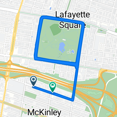
2015 Cranksgiving (12 Miles)
A cycling route starting in St Louis, Missouri, United States.OverviewAbout this route
12 mile route for the St. Louis Cranksgiving bicycle ride and food drive.
- -:--
- Duration
- 18.4 km
- Distance
- 146 m
- Ascent
- 141 m
- Descent
- ---
- Avg. speed
- ---
- Max. altitude
Waytypes
Road
8.5 km46 %Quiet road
5.1 km28 %
Surfaces
Paved
5.7 km(31 %)Asphalt
5 km27 %Paved (undefined)
0.4 km2 %
Free features
- Save this route as favorite or in collections
- Copy & plan your own version of this route
- Sync your route with Garmin or Wahoo
Premium features
Free trial for 3 days, or one-time payment. More about Bikemap Premium.
- Navigate this route on iOS & Android
- Export a GPX / KML file of this route
- Create your custom printout (try it for free)
- Download this route for offline navigation
Discover more Premium features.
Get Bikemap Premium- North Tucker Boulevard 100-110 to Wyoming Street
- 8.9 km
- 106 m
- 52 m
- St Louis, Missouri, United States
- Rutger St, St. Louis to Rutger St, St. Louis
- 4.3 km
- 38 m
- 48 m
- St Louis, Missouri, United States
- Allen Ave, St. Louis to Allen Ave, St. Louis
- 18 km
- 65 m
- 66 m
- St Louis, Missouri, United States
- Day 26
- 87.2 km
- 156 m
- 118 m
- St Louis, Missouri, United States
- Eerste dag
- 84.6 km
- 188 m
- 154 m
- St Louis, Missouri, United States
- STLtoLR2
- 1,129.9 km
- 1,218 m
- 1,282 m
- St Louis, Missouri, United States


Open it in the app