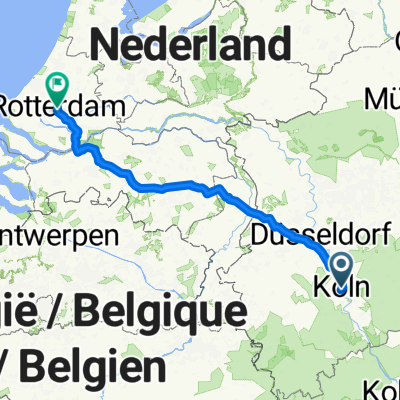
Königsforst Wahner-Heide Radtour
A cycling route starting in Altstadt Nord, North Rhine-Westphalia, Germany.
Overview
About this route
in unmittelbarer Nähe zum Ballungsgebiet der Rheinschiene bilden die Wahner Heide und der Königsforst einen ganz besonderen Landschaftsraum von europäischer Bedeutung, der eine Vielzahl ökologisch sensibler Flächen aufweist.
- -:--
- Duration
- 58.4 km
- Distance
- 140 m
- Ascent
- 140 m
- Descent
- ---
- Avg. speed
- ---
- Avg. speed
Route highlights
Points of interest along the route
Accommodation after 30.5 km
Jägerhof Altenrath Wahner Heide, Rambusch 1A, 53842 Troisdorf Telefon: 02246 2087991
Continue with Bikemap
Use, edit, or download this cycling route
You would like to ride Königsforst Wahner-Heide Radtour or customize it for your own trip? Here is what you can do with this Bikemap route:
Free features
- Save this route as favorite or in collections
- Copy & plan your own version of this route
- Sync your route with Garmin or Wahoo
Premium features
Free trial for 3 days, or one-time payment. More about Bikemap Premium.
- Navigate this route on iOS & Android
- Export a GPX / KML file of this route
- Create your custom printout (try it for free)
- Download this route for offline navigation
Discover more Premium features.
Get Bikemap PremiumFrom our community
Other popular routes starting in Altstadt Nord
- Leichlingen Radtour
- Distance
- 62.3 km
- Ascent
- 172 m
- Descent
- 176 m
- Location
- Altstadt Nord, North Rhine-Westphalia, Germany
- CYCLING THE RHINE: Route 10A
- Distance
- 65.9 km
- Ascent
- 147 m
- Descent
- 138 m
- Location
- Altstadt Nord, North Rhine-Westphalia, Germany
- Köln - Koblenz
- Distance
- 95.1 km
- Ascent
- 123 m
- Descent
- 104 m
- Location
- Altstadt Nord, North Rhine-Westphalia, Germany
- Köln . kleine Rheinrunde
- Distance
- 25.9 km
- Ascent
- 130 m
- Descent
- 130 m
- Location
- Altstadt Nord, North Rhine-Westphalia, Germany
- Forstbotanischer Garten, Köln
- Distance
- 7.5 km
- Ascent
- 41 m
- Descent
- 34 m
- Location
- Altstadt Nord, North Rhine-Westphalia, Germany
- Im rechtsrheinischen Grüngürtel
- Distance
- 30.8 km
- Ascent
- 77 m
- Descent
- 67 m
- Location
- Altstadt Nord, North Rhine-Westphalia, Germany
- CYCLING THE RHINE: Route R11A
- Distance
- 59.2 km
- Ascent
- 97 m
- Descent
- 108 m
- Location
- Altstadt Nord, North Rhine-Westphalia, Germany
- Breite - A4 - Deutz - Zoobrücke - Hbf
- Distance
- 20.5 km
- Ascent
- 141 m
- Descent
- 145 m
- Location
- Altstadt Nord, North Rhine-Westphalia, Germany
Open it in the app