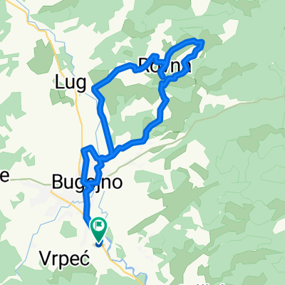
Recording from 27. oktobar 14:23
A cycling route starting in Bugojno, Federation of Bosnia and Herzegovina, Bosnia and Herzegovina.
Overview
About this route
- 1 h 30 min
- Duration
- 24.4 km
- Distance
- 164 m
- Ascent
- 161 m
- Descent
- 16.2 km/h
- Avg. speed
- ---
- Avg. speed
Route quality
Waytypes & surfaces along the route
Waytypes
Quiet road
11.3 km
(46 %)
Road
8.6 km
(35 %)
Surfaces
Paved
15.8 km
(65 %)
Unpaved
0.1 km
(<1 %)
Asphalt
15 km
(61 %)
Paved (undefined)
0.8 km
(3 %)
Route highlights
Points of interest along the route
Point of interest after 19.5 km
Continue with Bikemap
Use, edit, or download this cycling route
You would like to ride Recording from 27. oktobar 14:23 or customize it for your own trip? Here is what you can do with this Bikemap route:
Free features
- Save this route as favorite or in collections
- Copy & plan your own version of this route
- Sync your route with Garmin or Wahoo
Premium features
Free trial for 3 days, or one-time payment. More about Bikemap Premium.
- Navigate this route on iOS & Android
- Export a GPX / KML file of this route
- Create your custom printout (try it for free)
- Download this route for offline navigation
Discover more Premium features.
Get Bikemap PremiumFrom our community
Other popular routes starting in Bugojno
- Recording from 18. septembar 11:04
- Distance
- 31.2 km
- Ascent
- 350 m
- Descent
- 352 m
- Location
- Bugojno, Federation of Bosnia and Herzegovina, Bosnia and Herzegovina
- Bosnia trip from 2013
- Distance
- 183.4 km
- Ascent
- 1,076 m
- Descent
- 2,251 m
- Location
- Bugojno, Federation of Bosnia and Herzegovina, Bosnia and Herzegovina
- Bugojno - Rostovo
- Distance
- 25.5 km
- Ascent
- 549 m
- Descent
- 549 m
- Location
- Bugojno, Federation of Bosnia and Herzegovina, Bosnia and Herzegovina
- Bosanska, Bugojno to Unnamed Road
- Distance
- 64.5 km
- Ascent
- 1,139 m
- Descent
- 1,064 m
- Location
- Bugojno, Federation of Bosnia and Herzegovina, Bosnia and Herzegovina
- Bugojno - Livno - Glamoč - Jajce - Bugojno
- Distance
- 230.9 km
- Ascent
- 1,974 m
- Descent
- 1,974 m
- Location
- Bugojno, Federation of Bosnia and Herzegovina, Bosnia and Herzegovina
- Recording from 27. oktobar 14:23
- Distance
- 24.4 km
- Ascent
- 164 m
- Descent
- 161 m
- Location
- Bugojno, Federation of Bosnia and Herzegovina, Bosnia and Herzegovina
- Bugojno - Brela
- Distance
- 150 km
- Ascent
- 1,327 m
- Descent
- 1,909 m
- Location
- Bugojno, Federation of Bosnia and Herzegovina, Bosnia and Herzegovina
- Kupres-Ajvatovica-Duboka-Kukavičje jezero
- Distance
- 66.2 km
- Ascent
- 1,140 m
- Descent
- 1,140 m
- Location
- Bugojno, Federation of Bosnia and Herzegovina, Bosnia and Herzegovina
Open it in the app