

Chantemerle 2
A cycling route starting in Montségur-sur-Lauzon, Auvergne-Rhône-Alpes, France.
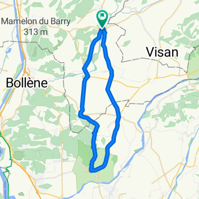
Overview
About this route
partially quiet streets, partially more traffic but wider streets
- -:--
- Duration
- 48.1 km
- Distance
- 388 m
- Ascent
- 388 m
- Descent
- ---
- Avg. speed
- ---
- Max. altitude

Continue with Bikemap
Use, edit, or download this cycling route
You would like to ride Chantemerle 2 or customize it for your own trip? Here is what you can do with this Bikemap route:
Free features
- Save this route as favorite or in collections
- Copy & plan your own version of this route
- Sync your route with Garmin or Wahoo
Premium features
Free trial for 3 days, or one-time payment. More about Bikemap Premium.
- Navigate this route on iOS & Android
- Export a GPX / KML file of this route
- Create your custom printout (try it for free)
- Download this route for offline navigation
Discover more Premium features.
Get Bikemap PremiumFrom our community
Other popular routes starting in Montségur-sur-Lauzon
 Parcours jour(s) de Mistral
- Distance
- 82.4 km
- Ascent
- 740 m
- Descent
- 713 m
- Location
- Montségur-sur-Lauzon, Auvergne-Rhône-Alpes, France
 Clansayes 2
- Distance
- 72.7 km
- Ascent
- 724 m
- Descent
- 739 m
- Location
- Montségur-sur-Lauzon, Auvergne-Rhône-Alpes, France
 la baume de transit 39.5 km
- Distance
- 39.4 km
- Ascent
- 163 m
- Descent
- 172 m
- Location
- Montségur-sur-Lauzon, Auvergne-Rhône-Alpes, France
 Sortie mensuelle Suzette Propiac
- Distance
- 141 km
- Ascent
- 2,233 m
- Descent
- 2,176 m
- Location
- Montségur-sur-Lauzon, Auvergne-Rhône-Alpes, France
 Bollene-Roussas-Grillon 65
- Distance
- 65.8 km
- Ascent
- 308 m
- Descent
- 301 m
- Location
- Montségur-sur-Lauzon, Auvergne-Rhône-Alpes, France
 Bollenè-Roussas
- Distance
- 69.8 km
- Ascent
- 671 m
- Descent
- 672 m
- Location
- Montségur-sur-Lauzon, Auvergne-Rhône-Alpes, France
 Bordette Ey Propiac
- Distance
- 112.9 km
- Ascent
- 2,062 m
- Descent
- 2,001 m
- Location
- Montségur-sur-Lauzon, Auvergne-Rhône-Alpes, France
 Ostern 2011
- Distance
- 69.1 km
- Ascent
- 710 m
- Descent
- 710 m
- Location
- Montségur-sur-Lauzon, Auvergne-Rhône-Alpes, France
Open it in the app