

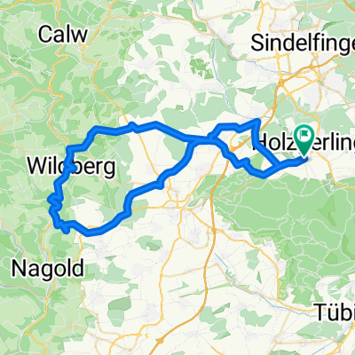
Altdorf Teufrlsbrücke Jagdbrücke
A cycling route starting in Altdorf, Baden-Wurttemberg, Germany.
Overview
About this route
<p>
08.07.13 19:49 (cloned from route 2220688)</p>
Translated, show original (German)- -:--
- Duration
- 31.6 km
- Distance
- 505 m
- Ascent
- 503 m
- Descent
- ---
- Avg. speed
- ---
- Max. altitude
Route quality
Waytypes & surfaces along the route
Waytypes
Track
26.2 km
(83 %)
Quiet road
3.8 km
(12 %)
Access road
1.6 km
(5 %)
Surfaces
Paved
6.3 km
(20 %)
Unpaved
24.6 km
(78 %)
Gravel
19.3 km
(61 %)
Asphalt
6 km
(19 %)
Continue with Bikemap
Use, edit, or download this cycling route
You would like to ride Altdorf Teufrlsbrücke Jagdbrücke or customize it for your own trip? Here is what you can do with this Bikemap route:
Free features
- Save this route as favorite or in collections
- Copy & plan your own version of this route
- Sync your route with Garmin or Wahoo
Premium features
Free trial for 3 days, or one-time payment. More about Bikemap Premium.
- Navigate this route on iOS & Android
- Export a GPX / KML file of this route
- Create your custom printout (try it for free)
- Download this route for offline navigation
Discover more Premium features.
Get Bikemap PremiumFrom our community
Other popular routes starting in Altdorf
 freedom - tour
- Distance
- 59.3 km
- Ascent
- 784 m
- Descent
- 790 m
- Location
- Altdorf, Baden-Wurttemberg, Germany
 3 D-K Tübingen - Rohrdorf
- Distance
- 96.6 km
- Ascent
- 1,205 m
- Descent
- 1,081 m
- Location
- Altdorf, Baden-Wurttemberg, Germany
 Altdorfer Feierabend
- Distance
- 20.9 km
- Ascent
- 169 m
- Descent
- 170 m
- Location
- Altdorf, Baden-Wurttemberg, Germany
 Altdorf - Lichtenstein
- Distance
- 104.3 km
- Ascent
- 845 m
- Descent
- 845 m
- Location
- Altdorf, Baden-Wurttemberg, Germany
 Radtour für Motorradfahrer
- Distance
- 32 km
- Ascent
- 367 m
- Descent
- 367 m
- Location
- Altdorf, Baden-Wurttemberg, Germany
 26.09.2023
- Distance
- 61.5 km
- Ascent
- 853 m
- Descent
- 826 m
- Location
- Altdorf, Baden-Wurttemberg, Germany
 Schönbuchtour mit Matze
- Distance
- 26 km
- Ascent
- 375 m
- Descent
- 373 m
- Location
- Altdorf, Baden-Wurttemberg, Germany
 Feierabend-Schönbuch-Runde extended
- Distance
- 30.6 km
- Ascent
- 293 m
- Descent
- 291 m
- Location
- Altdorf, Baden-Wurttemberg, Germany
Open it in the app