

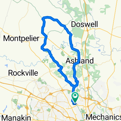
West End to MCV
A cycling route starting in Laurel, Virginia, United States.
Overview
About this route
How to bike from the west end to dfowntown
- -:--
- Duration
- 15 km
- Distance
- 76 m
- Ascent
- 89 m
- Descent
- ---
- Avg. speed
- ---
- Max. altitude
Route quality
Waytypes & surfaces along the route
Waytypes
Road
5.4 km
(36 %)
Busy road
5.1 km
(34 %)
Surfaces
Paved
7 km
(47 %)
Asphalt
6.3 km
(42 %)
Paved (undefined)
0.6 km
(4 %)
Continue with Bikemap
Use, edit, or download this cycling route
You would like to ride West End to MCV or customize it for your own trip? Here is what you can do with this Bikemap route:
Free features
- Save this route as favorite or in collections
- Copy & plan your own version of this route
- Sync your route with Garmin or Wahoo
Premium features
Free trial for 3 days, or one-time payment. More about Bikemap Premium.
- Navigate this route on iOS & Android
- Export a GPX / KML file of this route
- Create your custom printout (try it for free)
- Download this route for offline navigation
Discover more Premium features.
Get Bikemap PremiumFrom our community
Other popular routes starting in Laurel
 Laurel-Ashland loop
- Distance
- 30.3 km
- Ascent
- 62 m
- Descent
- 64 m
- Location
- Laurel, Virginia, United States
 West End to MCV
- Distance
- 15 km
- Ascent
- 76 m
- Descent
- 89 m
- Location
- Laurel, Virginia, United States
 Glen Allen Short Ride
- Distance
- 11.2 km
- Ascent
- 65 m
- Descent
- 68 m
- Location
- Laurel, Virginia, United States
 tiukukkuu
- Distance
- 8 km
- Ascent
- 70 m
- Descent
- 80 m
- Location
- Laurel, Virginia, United States
 9916 Mistyview Ct, Glen Allen to 9921 Mistyview Ct, Glen Allen
- Distance
- 8.1 km
- Ascent
- 21 m
- Descent
- 22 m
- Location
- Laurel, Virginia, United States
 Lidl2
Lidl2- Distance
- 5.4 km
- Ascent
- 47 m
- Descent
- 27 m
- Location
- Laurel, Virginia, United States
 4804 Mill Park Dr, Glen Allen to 4905 Dunncroft Ct, Glen Allen
- Distance
- 17 km
- Ascent
- 93 m
- Descent
- 95 m
- Location
- Laurel, Virginia, United States
 45 miles LP JUN 9
- Distance
- 72.5 km
- Ascent
- 148 m
- Descent
- 149 m
- Location
- Laurel, Virginia, United States
Open it in the app