

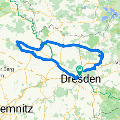
DD-Bad Schandau-Hohnstein-DD
A cycling route starting in Dresden, Saxony, Germany.
Overview
About this route
DD - Albertbrücke - Blaues Wunder - Kleinzschachwitz / Pillnitz - Zschieren - Heidenau - Pirna - Ebenheit - Struppen - Königstein - Elbbrücke Bad Schandau - Porschdorf - Hohnstein - Polenztal - Hocksteinschänke - Rathewalde - Lohmen - Dorf Wehlen - Mockethal - Zatzschke - Graupa - Oberpoyritz - Pillnitz - Blaues Wunder - Marienbrücke - DD
(cloned from route 20408)
- -:--
- Duration
- 91.6 km
- Distance
- 536 m
- Ascent
- 539 m
- Descent
- ---
- Avg. speed
- ---
- Max. altitude
Route quality
Waytypes & surfaces along the route
Waytypes
Path
14.7 km
(16 %)
Cycleway
14.7 km
(16 %)
Surfaces
Paved
81.5 km
(89 %)
Unpaved
0.9 km
(1 %)
Asphalt
81.5 km
(89 %)
Loose gravel
0.9 km
(1 %)
Undefined
9.2 km
(10 %)
Route highlights
Points of interest along the route
Point of interest after 0 km
START
Continue with Bikemap
Use, edit, or download this cycling route
You would like to ride DD-Bad Schandau-Hohnstein-DD or customize it for your own trip? Here is what you can do with this Bikemap route:
Free features
- Save this route as favorite or in collections
- Copy & plan your own version of this route
- Split it into stages to create a multi-day tour
- Sync your route with Garmin or Wahoo
Premium features
Free trial for 3 days, or one-time payment. More about Bikemap Premium.
- Navigate this route on iOS & Android
- Export a GPX / KML file of this route
- Create your custom printout (try it for free)
- Download this route for offline navigation
Discover more Premium features.
Get Bikemap PremiumFrom our community
Other popular routes starting in Dresden
 Pre Velorace Trainingsausfahrt 2015 Einsteiger
- Distance
- 44.6 km
- Ascent
- 222 m
- Descent
- 222 m
- Location
- Dresden, Saxony, Germany
 Ponickau
- Distance
- 122.5 km
- Ascent
- 320 m
- Descent
- 323 m
- Location
- Dresden, Saxony, Germany
 Dresden - Stolpen -Rathen
- Distance
- 54 km
- Ascent
- 447 m
- Descent
- 446 m
- Location
- Dresden, Saxony, Germany
 Dresden - Glashütte - Bahratal
- Distance
- 90.4 km
- Ascent
- 1,112 m
- Descent
- 1,142 m
- Location
- Dresden, Saxony, Germany
 Müglitztal - Königstein - Breitenau
- Distance
- 156 km
- Ascent
- 2,539 m
- Descent
- 2,398 m
- Location
- Dresden, Saxony, Germany
 cielab.org - Dresden - Bahratal - Mückentürmchen
- Distance
- 130 km
- Ascent
- 1,524 m
- Descent
- 1,516 m
- Location
- Dresden, Saxony, Germany
 Strecke - Erdgas Race Day-Speed-Challenge 2009
- Distance
- 63.4 km
- Ascent
- 515 m
- Descent
- 496 m
- Location
- Dresden, Saxony, Germany
 DD-Collm-Riesa-Keulenberg-DD
- Distance
- 196.8 km
- Ascent
- 1,000 m
- Descent
- 904 m
- Location
- Dresden, Saxony, Germany
Open it in the app