

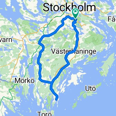
Recording from 31 October 11:18
A cycling route starting in Älta, Stockholm County, Sweden.
Overview
About this route
- 2 h 36 min
- Duration
- 24.6 km
- Distance
- 190 m
- Ascent
- 190 m
- Descent
- 9.5 km/h
- Avg. speed
- ---
- Max. altitude

Continue with Bikemap
Use, edit, or download this cycling route
You would like to ride Recording from 31 October 11:18 or customize it for your own trip? Here is what you can do with this Bikemap route:
Free features
- Save this route as favorite or in collections
- Copy & plan your own version of this route
- Sync your route with Garmin or Wahoo
Premium features
Free trial for 3 days, or one-time payment. More about Bikemap Premium.
- Navigate this route on iOS & Android
- Export a GPX / KML file of this route
- Create your custom printout (try it for free)
- Download this route for offline navigation
Discover more Premium features.
Get Bikemap PremiumFrom our community
Other popular routes starting in Älta
 Skarpnäck-Skeppsvik I
- Distance
- 137 km
- Ascent
- 332 m
- Descent
- 338 m
- Location
- Älta, Stockholm County, Sweden
 Stora tungelstarundan
- Distance
- 71.2 km
- Ascent
- 288 m
- Descent
- 290 m
- Location
- Älta, Stockholm County, Sweden
 Sköndal-Huddinge-Lissma-Länna-Sköndal
- Distance
- 32.7 km
- Ascent
- 275 m
- Descent
- 269 m
- Location
- Älta, Stockholm County, Sweden
 Farsta - Rosenhill
- Distance
- 27.1 km
- Ascent
- 256 m
- Descent
- 278 m
- Location
- Älta, Stockholm County, Sweden
 Bagarmossen - Nynäshamn - Bagarmossen
- Distance
- 123.4 km
- Ascent
- 351 m
- Descent
- 352 m
- Location
- Älta, Stockholm County, Sweden
 Tyrestarundan
- Distance
- 51.3 km
- Ascent
- 254 m
- Descent
- 254 m
- Location
- Älta, Stockholm County, Sweden
 Drevan
- Distance
- 34.9 km
- Ascent
- 212 m
- Descent
- 196 m
- Location
- Älta, Stockholm County, Sweden
 Skarpnäck-Brevik
- Distance
- 22.8 km
- Ascent
- 203 m
- Descent
- 231 m
- Location
- Älta, Stockholm County, Sweden
Open it in the app