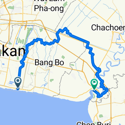
Bangplaring20k
A cycling route starting in Bang Bo District, Samut Prakan, Thailand.
Overview
About this route
Bangpla Bangpli
20km Â- -:--
- Duration
- 21.5 km
- Distance
- 8 m
- Ascent
- 8 m
- Descent
- ---
- Avg. speed
- ---
- Max. altitude
Route quality
Waytypes & surfaces along the route
Waytypes
Quiet road
9.9 km
(46 %)
Road
9.5 km
(44 %)
Surfaces
Paved
3 km
(14 %)
Asphalt
3 km
(14 %)
Undefined
18.5 km
(86 %)
Continue with Bikemap
Use, edit, or download this cycling route
You would like to ride Bangplaring20k or customize it for your own trip? Here is what you can do with this Bikemap route:
Free features
- Save this route as favorite or in collections
- Copy & plan your own version of this route
- Sync your route with Garmin or Wahoo
Premium features
Free trial for 3 days, or one-time payment. More about Bikemap Premium.
- Navigate this route on iOS & Android
- Export a GPX / KML file of this route
- Create your custom printout (try it for free)
- Download this route for offline navigation
Discover more Premium features.
Get Bikemap PremiumFrom our community
Other popular routes starting in Bang Bo District
- āļāļēāļāļāļđāđāļāļāļēāļ āļāļāļāļāļēāļāļāļē-āļāļĢāļēāļ 9/99, āļāļģāļāļĨāļāļēāļāđāļāļĨāļ to āļāļĢāļ°āđāļāļĻāđāļāļĒ, āļāļģāļāļĨāļāļēāļāđāļāļĨāļ
- Distance
- 0.4 km
- Ascent
- 0 m
- Descent
- 23 m
- Location
- Bang Bo District, Samut Prakan, Thailand
- Slow ride in Amphoe Bang Bo
- Distance
- 12.4 km
- Ascent
- 4 m
- Descent
- 10 m
- Location
- Bang Bo District, Samut Prakan, Thailand
- āļāļģāļāļĨāļāļēāļāđāļŠāļēāļāļ to āļāļģāđāļ āļāļāļĨāļāļāļŦāļĨāļ§āļ, āļāļģāļāļĨ āļāļĨāļāļāļŦāļāļķāđāļ
- Distance
- 79.4 km
- Ascent
- 450 m
- Descent
- 400 m
- Location
- Bang Bo District, Samut Prakan, Thailand
- Route in Amphoe Bang Sao Thong
- Distance
- 7.1 km
- Ascent
- 6 m
- Descent
- 4 m
- Location
- Bang Bo District, Samut Prakan, Thailand
- Steady ride in Amphoe Bang Phli
- Distance
- 14.5 km
- Ascent
- 0 m
- Descent
- 0 m
- Location
- Bang Bo District, Samut Prakan, Thailand
- Bangplaring20k
- Distance
- 21.5 km
- Ascent
- 8 m
- Descent
- 8 m
- Location
- Bang Bo District, Samut Prakan, Thailand
- HQXH+PF9, āļāļģāļāļĨāļāļēāļāđāļāļĨāļ to HQXH+PF9, āļāļģāļāļĨāļāļēāļāđāļāļĨāļ
- Distance
- 0.2 km
- Ascent
- 28 m
- Descent
- 17 m
- Location
- Bang Bo District, Samut Prakan, Thailand
- āļāļāļĒ āļŦāļĄāļđāđāļāđāļēāļāļāļēāļĢāđāļāļŦāļ°āļāļļāļĄāļāļāļāļēāļāļāļĨāļĩ 28, āļāļģāļāļĨāļāļēāļāđāļŠāļēāļāļ to āļāļģāļāļĨ āļāļķāļāļāļāļ
- Distance
- 77 km
- Ascent
- 200 m
- Descent
- 204 m
- Location
- Bang Bo District, Samut Prakan, Thailand
Open it in the app