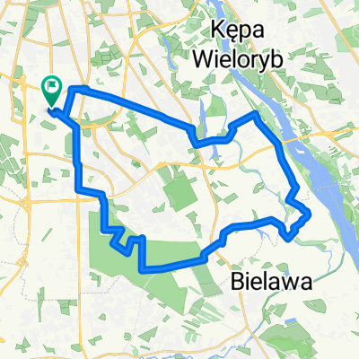
Puszcza-Leszno-Truskawki-Łomianki-Żoliborz
A cycling route starting in Mokotów, Masovian Voivodeship, Poland.
Overview
About this route
Puszcza-Leszno-Truskawki-Łomianki-Żoliborz
- -:--
- Duration
- 93.5 km
- Distance
- 98 m
- Ascent
- 98 m
- Descent
- ---
- Avg. speed
- ---
- Avg. speed
Route quality
Waytypes & surfaces along the route
Waytypes
Road
27.4 km
(29 %)
Busy road
22.5 km
(24 %)
Surfaces
Paved
78.7 km
(84 %)
Unpaved
0.6 km
(<1 %)
Asphalt
58.4 km
(62 %)
Paving stones
19.1 km
(20 %)
Continue with Bikemap
Use, edit, or download this cycling route
You would like to ride Puszcza-Leszno-Truskawki-Łomianki-Żoliborz or customize it for your own trip? Here is what you can do with this Bikemap route:
Free features
- Save this route as favorite or in collections
- Copy & plan your own version of this route
- Sync your route with Garmin or Wahoo
Premium features
Free trial for 3 days, or one-time payment. More about Bikemap Premium.
- Navigate this route on iOS & Android
- Export a GPX / KML file of this route
- Create your custom printout (try it for free)
- Download this route for offline navigation
Discover more Premium features.
Get Bikemap PremiumFrom our community
Other popular routes starting in Mokotów
- Pierwsza nocna przejażdżka
- Distance
- 28.2 km
- Ascent
- 58 m
- Descent
- 58 m
- Location
- Mokotów, Masovian Voivodeship, Poland
- Czerniaków, Las Kabacki, Las Natoliński, Rez. Morysin, p. Wilanowska, Czerniaków
- Distance
- 34.7 km
- Ascent
- 71 m
- Descent
- 69 m
- Location
- Mokotów, Masovian Voivodeship, Poland
- Niedziela z Kolarskim - 115 km
- Distance
- 115.5 km
- Ascent
- 139 m
- Descent
- 137 m
- Location
- Mokotów, Masovian Voivodeship, Poland
- Terenowa pętla
- Distance
- 55.4 km
- Ascent
- 80 m
- Descent
- 85 m
- Location
- Mokotów, Masovian Voivodeship, Poland
- niedzielna przejazdzka nie dla panienek
- Distance
- 91.9 km
- Ascent
- 67 m
- Descent
- 63 m
- Location
- Mokotów, Masovian Voivodeship, Poland
- Las Kabacki – Piaseczno – Chojnów – Zalesie Górne – Rezerwat przyrody Łoś – Lasy Sękocińskie
- Distance
- 86.9 km
- Ascent
- 151 m
- Descent
- 152 m
- Location
- Mokotów, Masovian Voivodeship, Poland
- Świdermajer
- Distance
- 62.7 km
- Ascent
- 51 m
- Descent
- 50 m
- Location
- Mokotów, Masovian Voivodeship, Poland
- Zalesie Górne
- Distance
- 40.1 km
- Ascent
- 92 m
- Descent
- 92 m
- Location
- Mokotów, Masovian Voivodeship, Poland