

Horner Runde
A cycling route starting in Horb am Neckar, Baden-Wurttemberg, Germany.
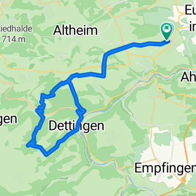
Overview
About this route
Runde Radfreizeitnachtreffen
- -:--
- Duration
- 49.1 km
- Distance
- 547 m
- Ascent
- 547 m
- Descent
- ---
- Avg. speed
- ---
- Max. altitude
Route quality
Waytypes & surfaces along the route
Waytypes
Track
13.3 km
(27 %)
Road
12.8 km
(26 %)
Surfaces
Paved
39.8 km
(81 %)
Unpaved
3.4 km
(7 %)
Asphalt
37.8 km
(77 %)
Paved (undefined)
2 km
(4 %)
Continue with Bikemap
Use, edit, or download this cycling route
You would like to ride Horner Runde or customize it for your own trip? Here is what you can do with this Bikemap route:
Free features
- Save this route as favorite or in collections
- Copy & plan your own version of this route
- Sync your route with Garmin or Wahoo
Premium features
Free trial for 3 days, or one-time payment. More about Bikemap Premium.
- Navigate this route on iOS & Android
- Export a GPX / KML file of this route
- Create your custom printout (try it for free)
- Download this route for offline navigation
Discover more Premium features.
Get Bikemap PremiumFrom our community
Other popular routes starting in Horb am Neckar
 Bildechingen-Obernau-Starzach
- Distance
- 42.6 km
- Ascent
- 490 m
- Descent
- 560 m
- Location
- Horb am Neckar, Baden-Wurttemberg, Germany
 Dienstag I
- Distance
- 30.3 km
- Ascent
- 411 m
- Descent
- 411 m
- Location
- Horb am Neckar, Baden-Wurttemberg, Germany
 Heubergstraße 7, Eutingen im Gäu nach Heubergstraße 5, Eutingen im Gäu
- Distance
- 20 km
- Ascent
- 89 m
- Descent
- 22 m
- Location
- Horb am Neckar, Baden-Wurttemberg, Germany
 Di4 - Im dunklen Wald
- Distance
- 32.8 km
- Ascent
- 610 m
- Descent
- 612 m
- Location
- Horb am Neckar, Baden-Wurttemberg, Germany
 Um die fischerwerke
- Distance
- 35.9 km
- Ascent
- 642 m
- Descent
- 591 m
- Location
- Horb am Neckar, Baden-Wurttemberg, Germany
 Ho-Gö-Ba-Vo-Ho
- Distance
- 19.1 km
- Ascent
- 154 m
- Descent
- 154 m
- Location
- Horb am Neckar, Baden-Wurttemberg, Germany
 Aussichtsturm
- Distance
- 42.5 km
- Ascent
- 481 m
- Descent
- 494 m
- Location
- Horb am Neckar, Baden-Wurttemberg, Germany
 IHLINGEN BODENSEE
- Distance
- 104.3 km
- Ascent
- 1,769 m
- Descent
- 1,630 m
- Location
- Horb am Neckar, Baden-Wurttemberg, Germany
Open it in the app