

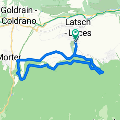
Vinschgau Schnalstal: Tarsch-Naturns-Vernagtsee-Kurzras
A cycling route starting in Latsch, Trentino-Alto Adige, Italy.
Overview
About this route
In schöner Landschaft mit gleichmäßiger Steigung ins Schnalstal. Die Rückfahrt ist bei guter Strassendecke rasant und viel zu schnell vorbei. (Wie immer sind Urlauns/Tagesziele nicht am Wochenende zzu empfehlen, in der Woche schon fast einsam)
- -:--
- Duration
- 32.9 km
- Distance
- 1,542 m
- Ascent
- 355 m
- Descent
- ---
- Avg. speed
- ---
- Max. altitude

Route highlights
Points of interest along the route
Point of interest after 23.3 km
Laufstart
Point of interest after 32.9 km
Ziel
Continue with Bikemap
Use, edit, or download this cycling route
You would like to ride Vinschgau Schnalstal: Tarsch-Naturns-Vernagtsee-Kurzras or customize it for your own trip? Here is what you can do with this Bikemap route:
Free features
- Save this route as favorite or in collections
- Copy & plan your own version of this route
- Sync your route with Garmin or Wahoo
Premium features
Free trial for 3 days, or one-time payment. More about Bikemap Premium.
- Navigate this route on iOS & Android
- Export a GPX / KML file of this route
- Create your custom printout (try it for free)
- Download this route for offline navigation
Discover more Premium features.
Get Bikemap PremiumFrom our community
Other popular routes starting in Latsch
 Tour zur Marzoner Alm
- Distance
- 30.5 km
- Ascent
- 1,142 m
- Descent
- 1,166 m
- Location
- Latsch, Trentino-Alto Adige, Italy
 Latscher Trail Zauber S2 (gross)
- Distance
- 15.8 km
- Ascent
- 552 m
- Descent
- 553 m
- Location
- Latsch, Trentino-Alto Adige, Italy
 Uphill Schloss-Annenberg
- Distance
- 13.8 km
- Ascent
- 1,125 m
- Descent
- 34 m
- Location
- Latsch, Trentino-Alto Adige, Italy
 LatscherAlm-TarscherAlm-MarzonerAlm Tour S2
- Distance
- 48.7 km
- Ascent
- 2,023 m
- Descent
- 2,024 m
- Location
- Latsch, Trentino-Alto Adige, Italy
 Latscher Trail Zauber S2 (klein)
- Distance
- 11.1 km
- Ascent
- 388 m
- Descent
- 394 m
- Location
- Latsch, Trentino-Alto Adige, Italy
 Transalp Schmuggler 4
- Distance
- 35.1 km
- Ascent
- 1,936 m
- Descent
- 1,324 m
- Location
- Latsch, Trentino-Alto Adige, Italy
 Martelltal bis zum Stausee
- Distance
- 48.9 km
- Ascent
- 1,551 m
- Descent
- 1,542 m
- Location
- Latsch, Trentino-Alto Adige, Italy
 Latscher - Tarscher - Alm
- Distance
- 27.3 km
- Ascent
- 1,393 m
- Descent
- 1,388 m
- Location
- Latsch, Trentino-Alto Adige, Italy
Open it in the app