

Glenelg East to the Blanche Harbour Shacks
A cycling route starting in Glenelg East, South Australia, Australia.
Overview
About this route
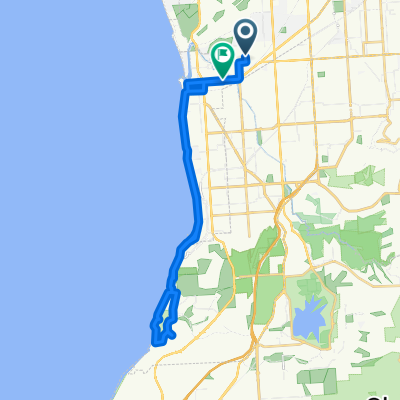
Just a big route from Glenelg East to the Blanche Harbour Shacks
- -:--
- Duration
- 337.4 km
- Distance
- 392 m
- Ascent
- 397 m
- Descent
- ---
- Avg. speed
- ---
- Max. altitude
Continue with Bikemap
Use, edit, or download this cycling route
You would like to ride Glenelg East to the Blanche Harbour Shacks or customize it for your own trip? Here is what you can do with this Bikemap route:
Free features
- Save this route as favorite or in collections
- Copy & plan your own version of this route
- Split it into stages to create a multi-day tour
- Sync your route with Garmin or Wahoo
Premium features
Free trial for 3 days, or one-time payment. More about Bikemap Premium.
- Navigate this route on iOS & Android
- Export a GPX / KML file of this route
- Create your custom printout (try it for free)
- Download this route for offline navigation
Discover more Premium features.
Get Bikemap PremiumFrom our community
Other popular routes starting in Glenelg East
 Easty ride west to Adelaide cityRoute to work
- Distance
- 9 km
- Ascent
- 50 m
- Descent
- 8 m
- Location
- Glenelg East, South Australia, Australia
 Camden Park - Marino Rocks - City Loop
- Distance
- 48.3 km
- Ascent
- 241 m
- Descent
- 239 m
- Location
- Glenelg East, South Australia, Australia
 Training - Home - Norton Summit - Lofty
- Distance
- 59.2 km
- Ascent
- 695 m
- Descent
- 693 m
- Location
- Glenelg East, South Australia, Australia
 Glenelg East to the Blanche Harbour Shacks
- Distance
- 337.4 km
- Ascent
- 392 m
- Descent
- 397 m
- Location
- Glenelg East, South Australia, Australia
 Camden Park to Willunga Hill
- Distance
- 98 km
- Ascent
- 1,186 m
- Descent
- 1,185 m
- Location
- Glenelg East, South Australia, Australia
 Pine ave to south tce - Mike Turtur Bikeway
- Distance
- 18.6 km
- Ascent
- 61 m
- Descent
- 61 m
- Location
- Glenelg East, South Australia, Australia
 Margie’s Way
- Distance
- 9.9 km
- Ascent
- 36 m
- Descent
- 0 m
- Location
- Glenelg East, South Australia, Australia
 Slow ride in Camden Park
- Distance
- 32.5 km
- Ascent
- 13 m
- Descent
- 22 m
- Location
- Glenelg East, South Australia, Australia
Open it in the app