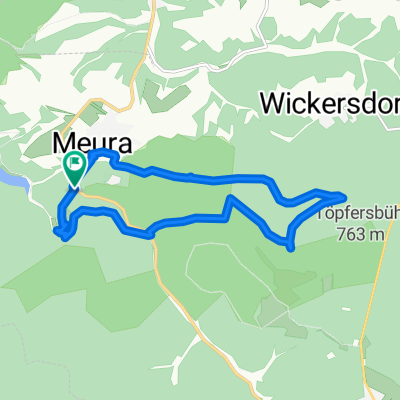
Schwarzatalrunde
- 44.5 km
- 438 m
- 416 m
- Meura, Thuringia, Germany
A cycling route starting in Meura, Thuringia, Germany.
Overview
Wanderung um die Talsperre
Ausgangspunkt: Parkplatz Meura
Talsperrenblick 'Schneiderfelsen' -
Staumauer (Unterweißbach) -
Talsperrenblick "Am Urian"
Vormauer Deesbach
bis zum Schluss Vorsperre Deesbach
auf der anderen Seite zurück
zum Parkplatz Meura
created this 10 years ago
Route quality
Access road
11 km
(51 %)
Track
9.9 km
(46 %)
Quiet road
0.6 km
(3 %)
Paved
10.8 km
(50 %)
Unpaved
10.1 km
(47 %)
Asphalt
10.8 km
(50 %)
Gravel
8.2 km
(38 %)
Route highlights

Start

... auf dem Weg ...

... zur Staumauer

Rast

Am Urian

auf dem Weg

Schluss

Blick auf Vorsperre

Mauer der Vorsperre


auf dem Rückweg
Continue with Bikemap
You would like to ride Rund um die Talsperre Leibis or customize it for your own trip? Here is what you can do with this Bikemap route:
Free trial for 3 days, or one-time payment. More about Bikemap Premium.
Discover more Premium features.
Get Bikemap PremiumFrom our community
Open it in the app