

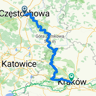
Częstochowa-Przewodziszowice-Złoty Potok-Częstochowa
A cycling route starting in Częstochowa, Silesian Voivodeship, Poland.
Overview
About this route
Szlakami między skałkami i ruinami zamków.
- -:--
- Duration
- 68.7 km
- Distance
- 356 m
- Ascent
- 356 m
- Descent
- ---
- Avg. speed
- ---
- Avg. speed

Route quality
Waytypes & surfaces along the route
Waytypes
Quiet road
18.9 km
(28 %)
Track
18 km
(26 %)
Surfaces
Paved
36.7 km
(53 %)
Unpaved
16.7 km
(24 %)
Asphalt
32.1 km
(47 %)
Ground
7.8 km
(11 %)
Continue with Bikemap
Use, edit, or download this cycling route
You would like to ride Częstochowa-Przewodziszowice-Złoty Potok-Częstochowa or customize it for your own trip? Here is what you can do with this Bikemap route:
Free features
- Save this route as favorite or in collections
- Copy & plan your own version of this route
- Sync your route with Garmin or Wahoo
Premium features
Free trial for 3 days, or one-time payment. More about Bikemap Premium.
- Navigate this route on iOS & Android
- Export a GPX / KML file of this route
- Create your custom printout (try it for free)
- Download this route for offline navigation
Discover more Premium features.
Get Bikemap PremiumFrom our community
Other popular routes starting in Częstochowa
 Częstochowa-Przewodziszowice-Złoty Potok-Częstochowa
- Distance
- 68.7 km
- Ascent
- 356 m
- Descent
- 356 m
- Location
- Częstochowa, Silesian Voivodeship, Poland
 Szlak Orlich Gniazd
- Distance
- 184.3 km
- Ascent
- 769 m
- Descent
- 812 m
- Location
- Częstochowa, Silesian Voivodeship, Poland
 Embajka w jurze
- Distance
- 208.3 km
- Ascent
- 885 m
- Descent
- 920 m
- Location
- Częstochowa, Silesian Voivodeship, Poland
 Częstochowa - Folwark Kamyk - Częstochowa 26,2 km
- Distance
- 26.2 km
- Ascent
- 86 m
- Descent
- 86 m
- Location
- Częstochowa, Silesian Voivodeship, Poland
 szlak orlich gniazd
- Distance
- 247 km
- Ascent
- 1,079 m
- Descent
- 1,122 m
- Location
- Częstochowa, Silesian Voivodeship, Poland
 Jurajski Szlak Rowerowy Orlich Gniazd
- Distance
- 177.7 km
- Ascent
- 766 m
- Descent
- 798 m
- Location
- Częstochowa, Silesian Voivodeship, Poland
 Po Jurze
- Distance
- 59.2 km
- Ascent
- 221 m
- Descent
- 220 m
- Location
- Częstochowa, Silesian Voivodeship, Poland
 Czestochowa-Dubrovnik
- Distance
- 1,358.7 km
- Ascent
- 2,201 m
- Descent
- 2,399 m
- Location
- Częstochowa, Silesian Voivodeship, Poland
Open it in the app