

4-Burgen-Tour Nothweiler
A cycling route starting in Nothweiler, Rhineland-Palatinate, Germany.
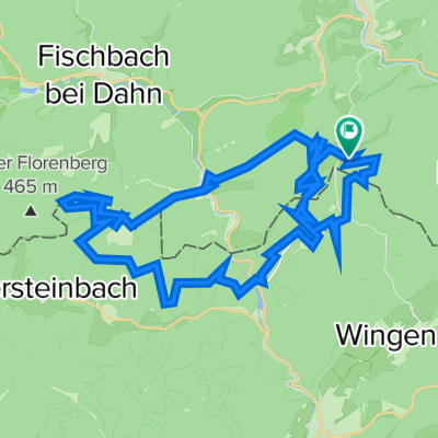
Overview
About this route
TEASI track
- -:--
- Duration
- 12.5 km
- Distance
- 518 m
- Ascent
- 518 m
- Descent
- ---
- Avg. speed
- ---
- Avg. speed
Route highlights
Points of interest along the route
Point of interest after 2.3 km
Die Wegelnburg gilt als die höchstgelegene (570 m ü. NN) Burg in der Pfalz. Die Burg wurde Ende des 12. Jahrhunderts als Reichsburg erbaut.<p />
Point of interest after 2.8 km
Maidenbrunnen
Point of interest after 3 km
1482 wurde die im 13. Jahrhundert errichtete Burg Eigentum der Herren von Sickingen. Franz von Sickingen ließ die Burg neu befestigen. Sie wurde jedoch 1523 zerstört und erst Jahrzehnte später erneut aufgebaut. Die Eingangstür aus der Renaissance ist zum Wahrzeichen der Anlage geworden.<p>
Point of interest after 3.2 km
Die im 12. Jahrhundert errichtete Burg ist wohl bereits im 13. Jahrhundert, als sich dort Raubritter verschanzten, endgültig zerstört worden. Später wurde sie wahrscheinlich als Vorposten der Hohenburg und der Burg Fleckenstein genutzt.<p>Löwenstein wird auch "Lindenschmitt" genannt. Der Sage nach
Point of interest after 5.6 km
P´tit Fleck
Point of interest after 6.9 km
Der Gimbelhof ist eine beliebte Ausflugsgaststätte nahe der deutsch-französischen Grenze.<p>Geöffnet: 8-23 Uhr - Warme Küche: 12-14 Uhr, 18-20:30 Uhr - Ruhetag: Mo./Di. • Tische: 25/120 Plätze</p>Das Ausflugslokal oberhalb von Lembach ist für Wanderer und Naturliebhaber geradezu ideal. Bei schönem
Point of interest after 7.1 km
Spielplatz Gimbelhof
Point of interest after 9.1 km
Wanderparkplatz
Continue with Bikemap
Use, edit, or download this cycling route
You would like to ride 4-Burgen-Tour Nothweiler or customize it for your own trip? Here is what you can do with this Bikemap route:
Free features
- Save this route as favorite or in collections
- Copy & plan your own version of this route
- Sync your route with Garmin or Wahoo
Premium features
Free trial for 3 days, or one-time payment. More about Bikemap Premium.
- Navigate this route on iOS & Android
- Export a GPX / KML file of this route
- Create your custom printout (try it for free)
- Download this route for offline navigation
Discover more Premium features.
Get Bikemap PremiumFrom our community
Other popular routes starting in Nothweiler
 Pfalz_Wandern_Franzburgen
- Distance
- 9.4 km
- Ascent
- 392 m
- Descent
- 392 m
- Location
- Nothweiler, Rhineland-Palatinate, Germany
 nach Ludwigswinkel
- Distance
- 18.5 km
- Ascent
- 538 m
- Descent
- 575 m
- Location
- Nothweiler, Rhineland-Palatinate, Germany
 Nothweiler
- Distance
- 17.4 km
- Ascent
- 532 m
- Descent
- 531 m
- Location
- Nothweiler, Rhineland-Palatinate, Germany
 Grenztour Dahner Felsenland/Nordvogesen, Nothweiler-Burg Fleckenstein (F) - Fischbach, Dahn-Nothweiler
- Distance
- 66.2 km
- Ascent
- 1,318 m
- Descent
- 1,241 m
- Location
- Nothweiler, Rhineland-Palatinate, Germany
 Nothweiler-Wissembourg-Lembach-Nothweiler (54km)
- Distance
- 55.4 km
- Ascent
- 1,415 m
- Descent
- 1,413 m
- Location
- Nothweiler, Rhineland-Palatinate, Germany
 6 Burgen 40km (1600HM)
- Distance
- 41.4 km
- Ascent
- 1,251 m
- Descent
- 1,254 m
- Location
- Nothweiler, Rhineland-Palatinate, Germany
 4-Burgen-Tour Nothweiler
- Distance
- 12.5 km
- Ascent
- 518 m
- Descent
- 518 m
- Location
- Nothweiler, Rhineland-Palatinate, Germany
 Marie Baumgartner - Naturpark Nordvogesen
- Distance
- 6.2 km
- Ascent
- 341 m
- Descent
- 341 m
- Location
- Nothweiler, Rhineland-Palatinate, Germany
Open it in the app