

Steinzeitmenschen und Wassermühlen in Wallhalben
A cycling route starting in Wallhalben, Rhineland-Palatinate, Germany.
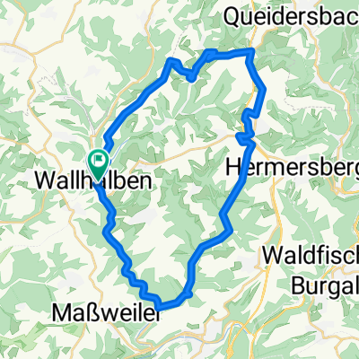
Overview
About this route
Around Wallhalben, there is plenty to discover: we start with the dwelling place of the Stone Age people, which lies between Rosendorf and Kneispermühle. Albert Westrich from Schmitshausen found this site about 25 years ago during excavations. The exact background can be read on an information panel.
- -:--
- Duration
- 14.6 km
- Distance
- 332 m
- Ascent
- 330 m
- Descent
- ---
- Avg. speed
- ---
- Max. altitude
Route quality
Waytypes & surfaces along the route
Waytypes
Track
10.4 km
(71 %)
Road
1.2 km
(8 %)
Surfaces
Paved
6.6 km
(45 %)
Unpaved
7 km
(48 %)
Asphalt
4.1 km
(28 %)
Unpaved (undefined)
3.6 km
(25 %)
Route highlights
Points of interest along the route
Point of interest after 1.2 km
Quelle
Point of interest after 1.4 km
Konradsmühle
Point of interest after 1.7 km
Blick auf Herschberg
Point of interest after 3.2 km
In der von 1440 stammenden, im Dreißigjährigen Krieg zerstörten und 1701 wieder aufgebauten Kneipsermühle befindet sich heute ein Gasthof. Die malerisch an einem Woog gelegene Waldgaststätte ist ein beliebtes Ausflugsziel. Mittwochs ist die Gaststätte allerdings geschlossen. <p>
Point of interest after 7.3 km
<b>Restaurant Pavillon:</b><u><p/><p/>Sommer (April - Oktober):</u> <p/>11.00 bis 22.00 Uhr Kein Ruhetag<p/><p/><u>Winter (Oktober - März):</u> <p/>Mo-Fr von 17.00 bis 22.00 Uhr<p/>Sa-So von 11.00 bis 22.00 Uhr<p/>Feiertag 11.00 bis 22.00 Uhr<b><p/><p/>Landgasthof Weihermühle:</b><p/><p/>April - Ok
Continue with Bikemap
Use, edit, or download this cycling route
You would like to ride Steinzeitmenschen und Wassermühlen in Wallhalben or customize it for your own trip? Here is what you can do with this Bikemap route:
Free features
- Save this route as favorite or in collections
- Copy & plan your own version of this route
- Sync your route with Garmin or Wahoo
Premium features
Free trial for 3 days, or one-time payment. More about Bikemap Premium.
- Navigate this route on iOS & Android
- Export a GPX / KML file of this route
- Create your custom printout (try it for free)
- Download this route for offline navigation
Discover more Premium features.
Get Bikemap PremiumFrom our community
Other popular routes starting in Wallhalben
 Wallhalben Tour
- Distance
- 31.1 km
- Ascent
- 411 m
- Descent
- 346 m
- Location
- Wallhalben, Rhineland-Palatinate, Germany
 Steinzeitmenschen und Wassermühlen in Wallhalben
- Distance
- 14.6 km
- Ascent
- 332 m
- Descent
- 330 m
- Location
- Wallhalben, Rhineland-Palatinate, Germany
 Pfalz M05 (Bärenhöhle)
- Distance
- 70.5 km
- Ascent
- 510 m
- Descent
- 507 m
- Location
- Wallhalben, Rhineland-Palatinate, Germany
 Pfalz M04 (Weihermühle)
- Distance
- 19.3 km
- Ascent
- 386 m
- Descent
- 385 m
- Location
- Wallhalben, Rhineland-Palatinate, Germany
 Fabrikstraße 20, Wallhalben to Kaiserstraße 50A, Landstuhl
- Distance
- 16.4 km
- Ascent
- 170 m
- Descent
- 180 m
- Location
- Wallhalben, Rhineland-Palatinate, Germany
 Corona-Tour | #16 für 2020
- Distance
- 86.4 km
- Ascent
- 181 m
- Descent
- 374 m
- Location
- Wallhalben, Rhineland-Palatinate, Germany
 Landstuhl_Homburg Rundtour
- Distance
- 70.7 km
- Ascent
- 399 m
- Descent
- 399 m
- Location
- Wallhalben, Rhineland-Palatinate, Germany
 Pfalz M06 (Kessel)
- Distance
- 19.6 km
- Ascent
- 410 m
- Descent
- 410 m
- Location
- Wallhalben, Rhineland-Palatinate, Germany
Open it in the app