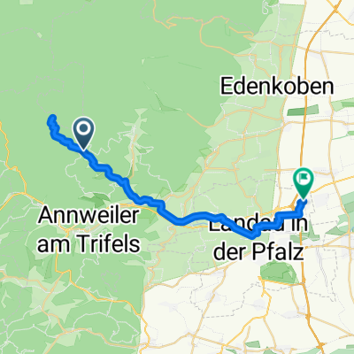
17-SEP-11
A cycling route starting in Eußerthal, Rhineland-Palatinate, Germany.
Overview
About this route
TEASI track
- -:--
- Duration
- 17.6 km
- Distance
- 626 m
- Ascent
- 626 m
- Descent
- ---
- Avg. speed
- ---
- Avg. speed
Route highlights
Points of interest along the route
Point of interest after 6 km
17-SEP-11 12:13:51
Point of interest after 9.1 km
17-SEP-11 13:08:18
Point of interest after 9.3 km
17-SEP-11 13:26:31
Point of interest after 12.4 km
17-SEP-11 15:29:21
Continue with Bikemap
Use, edit, or download this cycling route
You would like to ride 17-SEP-11 or customize it for your own trip? Here is what you can do with this Bikemap route:
Free features
- Save this route as favorite or in collections
- Copy & plan your own version of this route
- Sync your route with Garmin or Wahoo
Premium features
Free trial for 3 days, or one-time payment. More about Bikemap Premium.
- Navigate this route on iOS & Android
- Export a GPX / KML file of this route
- Create your custom printout (try it for free)
- Download this route for offline navigation
Discover more Premium features.
Get Bikemap PremiumFrom our community
Other popular routes starting in Eußerthal
- Von Platz Nr. 5 in Eußerthal zum Platz Nr. 6 am Modenbacher Hof
- Distance
- 16.4 km
- Ascent
- 691 m
- Descent
- 609 m
- Location
- Eußerthal, Rhineland-Palatinate, Germany
- 1Taubensuhl-JKreuz-Finsterbrunnertal-Z53
- Distance
- 25 km
- Ascent
- 181 m
- Descent
- 379 m
- Location
- Eußerthal, Rhineland-Palatinate, Germany
- 17-SEP-11
- Distance
- 17.6 km
- Ascent
- 626 m
- Descent
- 626 m
- Location
- Eußerthal, Rhineland-Palatinate, Germany
- Aufnahme vom 03.07.2016, 14:57
- Distance
- 26.9 km
- Ascent
- 270 m
- Descent
- 327 m
- Location
- Eußerthal, Rhineland-Palatinate, Germany
- Taubensuhl Bergzeitfahren
- Distance
- 6.6 km
- Ascent
- 439 m
- Descent
- 130 m
- Location
- Eußerthal, Rhineland-Palatinate, Germany
- Taubensuhl-Kalmit
- Distance
- 32.7 km
- Ascent
- 631 m
- Descent
- 998 m
- Location
- Eußerthal, Rhineland-Palatinate, Germany
- Taubensuhl 2, Landau in der Pfalz nach Ramburgstraße 1, Insheim
- Distance
- 27.7 km
- Ascent
- 232 m
- Descent
- 600 m
- Location
- Eußerthal, Rhineland-Palatinate, Germany
- Rheinebenetour Eußerthal Wörth zurück über Hörth und Bellheim
- Distance
- 98 km
- Ascent
- 175 m
- Descent
- 168 m
- Location
- Eußerthal, Rhineland-Palatinate, Germany
Open it in the app