

24-SEP-11
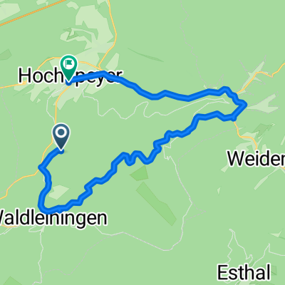
A cycling route starting in Waldleiningen, Rhineland-Palatinate, Germany.
Overview
About this route
TEASI track
- -:--
- Duration
- 13.5 km
- Distance
- 309 m
- Ascent
- 307 m
- Descent
- ---
- Avg. speed
- ---
- Max. altitude
Route highlights
Points of interest along the route
Point of interest after 4.5 km
24-SEP-11 12:17:07
Point of interest after 7.4 km
Stüterhof
Point of interest after 8.4 km
24-SEP-11 14:21:28
Point of interest after 9.9 km
24-SEP-11 14:50:58
Point of interest after 10.2 km
24-SEP-11 15:00:53
Point of interest after 12.8 km
24-SEP-11 16:20:48
Continue with Bikemap
Use, edit, or download this cycling route
You would like to ride 24-SEP-11 or customize it for your own trip? Here is what you can do with this Bikemap route:
Free features
- Save this route as favorite or in collections
- Copy & plan your own version of this route
- Sync your route with Garmin or Wahoo
Premium features
Free trial for 3 days, or one-time payment. More about Bikemap Premium.
- Navigate this route on iOS & Android
- Export a GPX / KML file of this route
- Create your custom printout (try it for free)
- Download this route for offline navigation
Discover more Premium features.
Get Bikemap PremiumFrom our community
Other popular routes starting in Waldleiningen
 Vatertag 2013
- Distance
- 20.1 km
- Ascent
- 429 m
- Descent
- 426 m
- Location
- Waldleiningen, Rhineland-Palatinate, Germany
 24-SEP-11
- Distance
- 13.5 km
- Ascent
- 309 m
- Descent
- 307 m
- Location
- Waldleiningen, Rhineland-Palatinate, Germany
 Waldleiningen nach Winterbach
- Distance
- 74.5 km
- Ascent
- 255 m
- Descent
- 294 m
- Location
- Waldleiningen, Rhineland-Palatinate, Germany
 Waldleiningen Bingen Campingplatz Hindenburgbrücke
- Distance
- 83.2 km
- Ascent
- 699 m
- Descent
- 866 m
- Location
- Waldleiningen, Rhineland-Palatinate, Germany
 Espensteig
- Distance
- 34.6 km
- Ascent
- 361 m
- Descent
- 363 m
- Location
- Waldleiningen, Rhineland-Palatinate, Germany
 Waldleiningen Dudweiler
- Distance
- 77 km
- Ascent
- 279 m
- Descent
- 310 m
- Location
- Waldleiningen, Rhineland-Palatinate, Germany
 Unnamed Road, Hochspeyer nach Kirchstraße 3, Hochspeyer
- Distance
- 21.6 km
- Ascent
- 244 m
- Descent
- 365 m
- Location
- Waldleiningen, Rhineland-Palatinate, Germany
 Daubenbornerhof
- Distance
- 39.1 km
- Ascent
- 316 m
- Descent
- 317 m
- Location
- Waldleiningen, Rhineland-Palatinate, Germany
Open it in the app