Wellige 65 km
A cycling route starting in Schellhorn, Schleswig-Holstein, Germany.
Overview
About this route
The route goes from Preetz towards Plön, then continues towards Malente. It is a very hilly course, with 499 meters of elevation gain according to the speedometer with barometric measurement. Perfect for a nice little road bike ride.
On gpsies.com, 345 meters of elevation are indicated for this route, here only 180. The 180 meters of elevation is clearly too little... (cloned from route 477243)- -:--
- Duration
- 64.5 km
- Distance
- 222 m
- Ascent
- 224 m
- Descent
- ---
- Avg. speed
- ---
- Max. altitude
Route quality
Waytypes & surfaces along the route
Waytypes
Quiet road
49.7 km
(77 %)
Road
9 km
(14 %)
Surfaces
Paved
26.4 km
(41 %)
Asphalt
23.2 km
(36 %)
Paved (undefined)
3.2 km
(5 %)
Undefined
38.1 km
(59 %)
Continue with Bikemap
Use, edit, or download this cycling route
You would like to ride Wellige 65 km or customize it for your own trip? Here is what you can do with this Bikemap route:
Free features
- Save this route as favorite or in collections
- Copy & plan your own version of this route
- Sync your route with Garmin or Wahoo
Premium features
Free trial for 3 days, or one-time payment. More about Bikemap Premium.
- Navigate this route on iOS & Android
- Export a GPX / KML file of this route
- Create your custom printout (try it for free)
- Download this route for offline navigation
Discover more Premium features.
Get Bikemap PremiumFrom our community
Other popular routes starting in Schellhorn
- 2Czweiter Tag/schellhorn/Selent/Hohwacht
- Distance
- 49.7 km
- Ascent
- 128 m
- Descent
- 160 m
- Location
- Schellhorn, Schleswig-Holstein, Germany
- wellige 65 km
- Distance
- 64.5 km
- Ascent
- 242 m
- Descent
- 244 m
- Location
- Schellhorn, Schleswig-Holstein, Germany
- Preetzer Straße 1, Lehmkuhlen nach Preetzer Straße 1-3, Lehmkuhlen
- Distance
- 29.3 km
- Ascent
- 125 m
- Descent
- 171 m
- Location
- Schellhorn, Schleswig-Holstein, Germany
- Schusteracht Südroute
- Distance
- 30.6 km
- Ascent
- 95 m
- Descent
- 95 m
- Location
- Schellhorn, Schleswig-Holstein, Germany
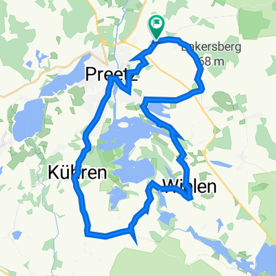
- Preetz - Wanderwege - Home (TTCP)
- Distance
- 41.1 km
- Ascent
- 141 m
- Descent
- 137 m
- Location
- Schellhorn, Schleswig-Holstein, Germany
- von acht
- Distance
- 29 km
- Ascent
- 179 m
- Descent
- 181 m
- Location
- Schellhorn, Schleswig-Holstein, Germany
- Rund Preetz
- Distance
- 58.1 km
- Ascent
- 158 m
- Descent
- 157 m
- Location
- Schellhorn, Schleswig-Holstein, Germany
- Preetz-Plön
- Distance
- 34.8 km
- Ascent
- 125 m
- Descent
- 125 m
- Location
- Schellhorn, Schleswig-Holstein, Germany
Open it in the app