

Avignon-Barcelona
A cycling route starting in Castillon-du-Gard, Occitanie, France.
Overview
About this route
France-Spain - Provence-Costa Brava
- -:--
- Duration
- 579.6 km
- Distance
- 565 m
- Ascent
- 575 m
- Descent
- ---
- Avg. speed
- ---
- Max. altitude
Route quality
Waytypes & surfaces along the route
Waytypes
Quiet road
179.7 km
(31 %)
Road
104.3 km
(18 %)
Surfaces
Paved
411.5 km
(71 %)
Unpaved
23.2 km
(4 %)
Asphalt
394.1 km
(68 %)
Gravel
17.4 km
(3 %)
Continue with Bikemap
Use, edit, or download this cycling route
You would like to ride Avignon-Barcelona or customize it for your own trip? Here is what you can do with this Bikemap route:
Free features
- Save this route as favorite or in collections
- Copy & plan your own version of this route
- Split it into stages to create a multi-day tour
- Sync your route with Garmin or Wahoo
Premium features
Free trial for 3 days, or one-time payment. More about Bikemap Premium.
- Navigate this route on iOS & Android
- Export a GPX / KML file of this route
- Create your custom printout (try it for free)
- Download this route for offline navigation
Discover more Premium features.
Get Bikemap PremiumFrom our community
Other popular routes starting in Castillon-du-Gard
 Le gardon Rhone
- Distance
- 36 km
- Ascent
- 115 m
- Descent
- 113 m
- Location
- Castillon-du-Gard, Occitanie, France
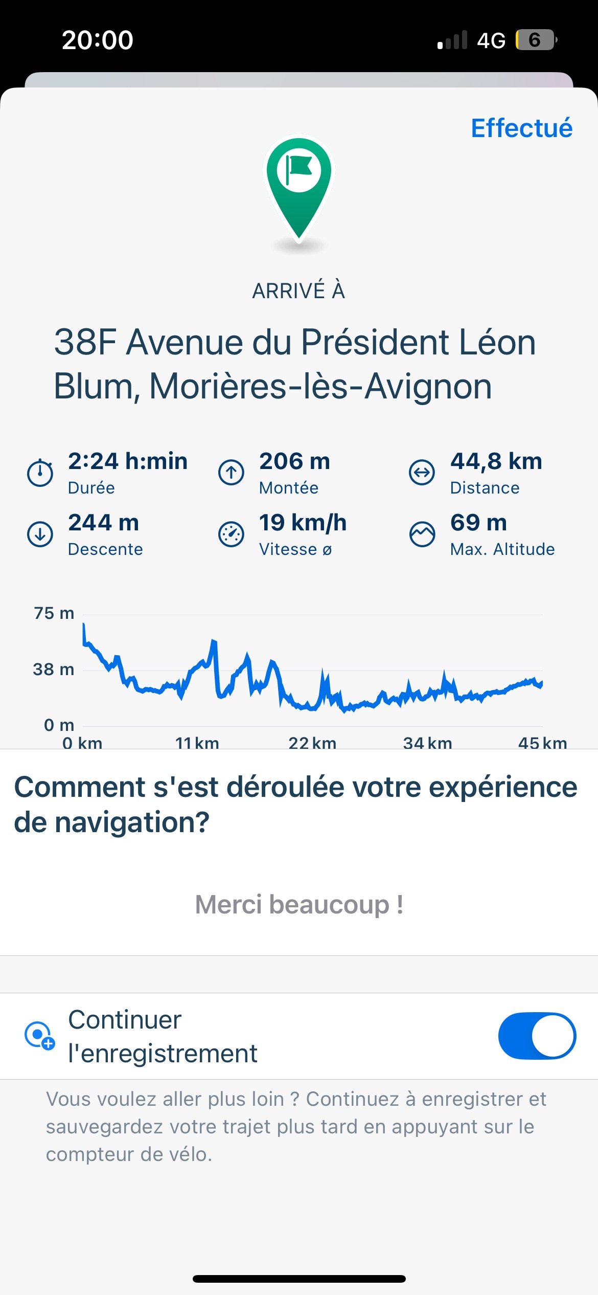 Chemin du Grès, Argilliers à Rue du Docteur S Bioules, Morières-lès-Avignon
- Distance
- 45.4 km
- Ascent
- 215 m
- Descent
- 244 m
- Location
- Castillon-du-Gard, Occitanie, France
 Avignon-Barcelona
- Distance
- 579.6 km
- Ascent
- 565 m
- Descent
- 575 m
- Location
- Castillon-du-Gard, Occitanie, France
 pont du gard
- Distance
- 87.1 km
- Ascent
- 923 m
- Descent
- 903 m
- Location
- Castillon-du-Gard, Occitanie, France
 Pont du Gard - Tarascon - Avignon
- Distance
- 62.4 km
- Ascent
- 196 m
- Descent
- 197 m
- Location
- Castillon-du-Gard, Occitanie, France
 La Soustra aux vestiges romain de Sernhac
- Distance
- 23.3 km
- Ascent
- 164 m
- Descent
- 165 m
- Location
- Castillon-du-Gard, Occitanie, France
 S_T5_ANT
- Distance
- 159 km
- Ascent
- 264 m
- Descent
- 277 m
- Location
- Castillon-du-Gard, Occitanie, France
 De Rue Théodore Aubanel 27, Saint-Hilaire-d'Ozilhan à Rue Alphonse Tavan 3, Saint-Hilaire-d'Ozilhan
- Distance
- 10.8 km
- Ascent
- 165 m
- Descent
- 169 m
- Location
- Castillon-du-Gard, Occitanie, France
Open it in the app