
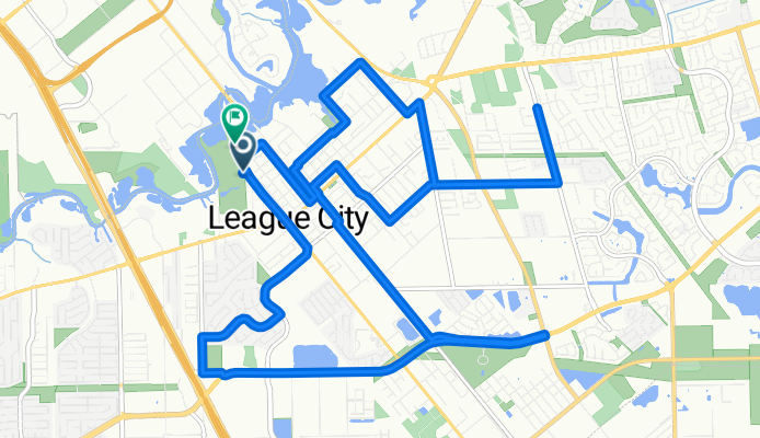
League City Texas Parks Tour (Bird's Head)
A cycling route starting in League City, Texas, United States.
Overview
About this route
Route is a tour of a few publc parks in League City, TX, a suburb to the southeast of Houston. Most of the parks have water and restroom facilities. The route uses mainly neighborhood streets as to avoid the traffic and vehicles traveling at higher rates of speed on the busier streets. Note: Hometown Heros Park (Eastern Regional Park) does have an exit on to Dickinson Ave at the back of the park so that riders can avoid busier traffic on League City Pkwy (HWY 96). If riders follow each point of interest in order on the route, the connecting lines of each point forms the shape of a bird's head.
- -:--
- Duration
- 24.5 km
- Distance
- 39 m
- Ascent
- 42 m
- Descent
- ---
- Avg. speed
- ---
- Max. altitude
Route quality
Waytypes & surfaces along the route
Waytypes
Road
10.5 km
(43 %)
Quiet road
8.2 km
(33 %)
Surfaces
Paved
0.4 km
(2 %)
Asphalt
0.3 km
(1 %)
Paved (undefined)
0.1 km
(<1 %)
Undefined
24.1 km
(98 %)
Continue with Bikemap
Use, edit, or download this cycling route
You would like to ride League City Texas Parks Tour (Bird's Head) or customize it for your own trip? Here is what you can do with this Bikemap route:
Free features
- Save this route as favorite or in collections
- Copy & plan your own version of this route
- Sync your route with Garmin or Wahoo
Premium features
Free trial for 3 days, or one-time payment. More about Bikemap Premium.
- Navigate this route on iOS & Android
- Export a GPX / KML file of this route
- Create your custom printout (try it for free)
- Download this route for offline navigation
Discover more Premium features.
Get Bikemap PremiumFrom our community
Other popular routes starting in League City
 HWY/FWY Flyer
- Distance
- 70.6 km
- Ascent
- 22 m
- Descent
- 25 m
- Location
- League City, Texas, United States
 first time
- Distance
- 4 km
- Ascent
- 0 m
- Descent
- 0 m
- Location
- League City, Texas, United States
 Mag Creek Loop with Spring Canyon Turnaround
- Distance
- 9.7 km
- Ascent
- 3 m
- Descent
- 3 m
- Location
- League City, Texas, United States
 Home to W market
- Distance
- 5.1 km
- Ascent
- 28 m
- Descent
- 12 m
- Location
- League City, Texas, United States
 Walter Hall Park to Lakeshore Dr.
- Distance
- 12 km
- Ascent
- 59 m
- Descent
- 42 m
- Location
- League City, Texas, United States
 league city loop 5
- Distance
- 12.8 km
- Ascent
- 61 m
- Descent
- 64 m
- Location
- League City, Texas, United States
 loop 6
- Distance
- 12.2 km
- Ascent
- 102 m
- Descent
- 121 m
- Location
- League City, Texas, United States
 Hayward League City 1
- Distance
- 21 km
- Ascent
- 116 m
- Descent
- 104 m
- Location
- League City, Texas, United States
Open it in the app