

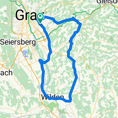
Graz-Stübingtal-Rohrbach-Thal-Graz
A cycling route starting in Graz, Styria, Austria.
Overview
About this route
On the cycling path in Graz, there is a short section of gravel road, otherwise it is consistently paved. In the Stübing valley, there may be many motorcyclists, otherwise it is quiet.
- -:--
- Duration
- 70.6 km
- Distance
- 743 m
- Ascent
- 696 m
- Descent
- ---
- Avg. speed
- 768 m
- Max. altitude
Route quality
Waytypes & surfaces along the route
Waytypes
Cycleway
17.6 km
(25 %)
Road
2.8 km
(4 %)
Surfaces
Paved
66.3 km
(94 %)
Unpaved
2.8 km
(4 %)
Asphalt
65.6 km
(93 %)
Gravel
2.8 km
(4 %)
Continue with Bikemap
Use, edit, or download this cycling route
You would like to ride Graz-Stübingtal-Rohrbach-Thal-Graz or customize it for your own trip? Here is what you can do with this Bikemap route:
Free features
- Save this route as favorite or in collections
- Copy & plan your own version of this route
- Sync your route with Garmin or Wahoo
Premium features
Free trial for 3 days, or one-time payment. More about Bikemap Premium.
- Navigate this route on iOS & Android
- Export a GPX / KML file of this route
- Create your custom printout (try it for free)
- Download this route for offline navigation
Discover more Premium features.
Get Bikemap PremiumFrom our community
Other popular routes starting in Graz
 2020-04-18
- Distance
- 43.4 km
- Ascent
- 420 m
- Descent
- 417 m
- Location
- Graz, Styria, Austria
 Freitagsrunde
- Distance
- 67.1 km
- Ascent
- 565 m
- Descent
- 530 m
- Location
- Graz, Styria, Austria
 Runde südwestlich von Graz, 13. Aug., 10:57 aufgenommen
- Distance
- 51.8 km
- Ascent
- 161 m
- Descent
- 166 m
- Location
- Graz, Styria, Austria
 Graz - Eggersdorf - Graz
- Distance
- 33.7 km
- Ascent
- 443 m
- Descent
- 443 m
- Location
- Graz, Styria, Austria
 Einsiedlerweg
- Distance
- 28.4 km
- Ascent
- 437 m
- Descent
- 428 m
- Location
- Graz, Styria, Austria
 Graz-Stübingtal-Rohrbach-Thal-Graz
- Distance
- 70.6 km
- Ascent
- 743 m
- Descent
- 696 m
- Location
- Graz, Styria, Austria
 Laßnitzhöhe - Vassoldsberg - Autal - Heim
- Distance
- 44.1 km
- Ascent
- 567 m
- Descent
- 568 m
- Location
- Graz, Styria, Austria
 Graz - Rechberg - Graz
- Distance
- 93.6 km
- Ascent
- 997 m
- Descent
- 991 m
- Location
- Graz, Styria, Austria
Open it in the app