
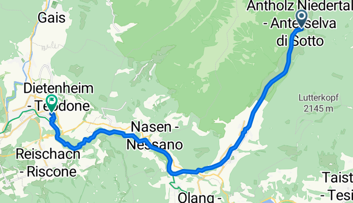
20150509_170346.gpx
A cycling route starting in Rasun Anterselva - Rasen-Antholz, Trentino-Alto Adige, Italy.
Overview
About this route
TEASI track
- -:--
- Duration
- 17.8 km
- Distance
- 62 m
- Ascent
- 316 m
- Descent
- ---
- Avg. speed
- ---
- Max. altitude

Route quality
Waytypes & surfaces along the route
Waytypes
Track
12.7 km
(71 %)
Quiet road
3.7 km
(21 %)
Surfaces
Paved
6.7 km
(37 %)
Unpaved
9.5 km
(53 %)
Asphalt
6.2 km
(35 %)
Gravel
5.6 km
(31 %)
Continue with Bikemap
Use, edit, or download this cycling route
You would like to ride 20150509_170346.gpx or customize it for your own trip? Here is what you can do with this Bikemap route:
Free features
- Save this route as favorite or in collections
- Copy & plan your own version of this route
- Sync your route with Garmin or Wahoo
Premium features
Free trial for 3 days, or one-time payment. More about Bikemap Premium.
- Navigate this route on iOS & Android
- Export a GPX / KML file of this route
- Create your custom printout (try it for free)
- Download this route for offline navigation
Discover more Premium features.
Get Bikemap PremiumFrom our community
Other popular routes starting in Rasun Anterselva - Rasen-Antholz
 anterselva
- Distance
- 6.5 km
- Ascent
- 180 m
- Descent
- 44 m
- Location
- Rasun Anterselva - Rasen-Antholz, Trentino-Alto Adige, Italy
 20100627, VSC & VSG, Rund um den Kronplatz CLONED FROM ROUTE 571716
- Distance
- 60 km
- Ascent
- 1,496 m
- Descent
- 1,496 m
- Location
- Rasun Anterselva - Rasen-Antholz, Trentino-Alto Adige, Italy
 e bike tour kreuzjoch senses platz
- Distance
- 113.5 km
- Ascent
- 2,984 m
- Descent
- 3,003 m
- Location
- Rasun Anterselva - Rasen-Antholz, Trentino-Alto Adige, Italy
 PASSO STALLER/ STALLER SATTER (por Niederrasen/Rasun di Sotto)
- Distance
- 23.3 km
- Ascent
- 1,281 m
- Descent
- 242 m
- Location
- Rasun Anterselva - Rasen-Antholz, Trentino-Alto Adige, Italy
 e bike extreme tour
- Distance
- 58.3 km
- Ascent
- 2,971 m
- Descent
- 2,968 m
- Location
- Rasun Anterselva - Rasen-Antholz, Trentino-Alto Adige, Italy
 MTB Gsieserdal
- Distance
- 50.4 km
- Ascent
- 1,142 m
- Descent
- 1,137 m
- Location
- Rasun Anterselva - Rasen-Antholz, Trentino-Alto Adige, Italy
 Val Pusteria 9) Giretto sciallo a Anterselva
- Distance
- 16.3 km
- Ascent
- 205 m
- Descent
- 202 m
- Location
- Rasun Anterselva - Rasen-Antholz, Trentino-Alto Adige, Italy
 Staller Sattel
- Distance
- 115.2 km
- Ascent
- 2,225 m
- Descent
- 2,225 m
- Location
- Rasun Anterselva - Rasen-Antholz, Trentino-Alto Adige, Italy
Open it in the app