

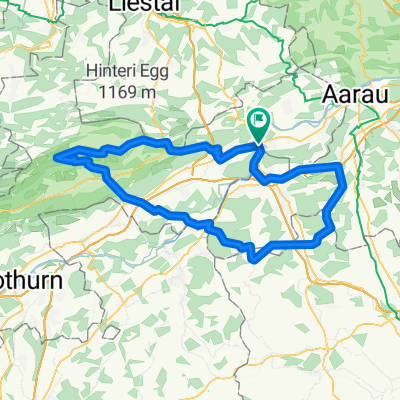
20151113 AG/BL/SO-Combo
A cycling route starting in Olten, Canton of Solothurn, Switzerland.
Overview
About this route
Olten - Lostorf - Balmis - Schafmatt - Oltingen - Oltinger Stich - Zeglingen - Wisen - Wisnerhöchi - Froburg - Unter Hauenstein - Läufelfingen - Laufmatt - Eptingen - Chilchzimmersattel/Belchenpass/Bölchen - Langenbruck - Teufelsschlucht - Hägendorf - Olten
- -:--
- Duration
- 60.1 km
- Distance
- 1,419 m
- Ascent
- 1,419 m
- Descent
- ---
- Avg. speed
- ---
- Max. altitude
Route quality
Waytypes & surfaces along the route
Waytypes
Road
44.3 km
(74 %)
Busy road
7.8 km
(13 %)
Surfaces
Paved
45.2 km
(75 %)
Unpaved
0.3 km
(<1 %)
Asphalt
43.8 km
(73 %)
Paved (undefined)
1.4 km
(2 %)
Continue with Bikemap
Use, edit, or download this cycling route
You would like to ride 20151113 AG/BL/SO-Combo or customize it for your own trip? Here is what you can do with this Bikemap route:
Free features
- Save this route as favorite or in collections
- Copy & plan your own version of this route
- Sync your route with Garmin or Wahoo
Premium features
Free trial for 3 days, or one-time payment. More about Bikemap Premium.
- Navigate this route on iOS & Android
- Export a GPX / KML file of this route
- Create your custom printout (try it for free)
- Download this route for offline navigation
Discover more Premium features.
Get Bikemap PremiumFrom our community
Other popular routes starting in Olten
 Oltiger stich
- Distance
- 42.6 km
- Ascent
- 884 m
- Descent
- 884 m
- Location
- Olten, Canton of Solothurn, Switzerland
 Schafmattrunde Olten
- Distance
- 37.3 km
- Ascent
- 909 m
- Descent
- 890 m
- Location
- Olten, Canton of Solothurn, Switzerland
 Glaubenberg, Glaubenbüehlen, Lüderealp
- Distance
- 208.4 km
- Ascent
- 2,690 m
- Descent
- 2,703 m
- Location
- Olten, Canton of Solothurn, Switzerland
 Olten - Hauenstein - Schaafmatt - Olten
- Distance
- 31.5 km
- Ascent
- 652 m
- Descent
- 655 m
- Location
- Olten, Canton of Solothurn, Switzerland
 Olten - Mümliswil - Brunnersberg - Kestenholz
- Distance
- 93.5 km
- Ascent
- 1,455 m
- Descent
- 1,454 m
- Location
- Olten, Canton of Solothurn, Switzerland
 Olten - Moutier
- Distance
- 58.8 km
- Ascent
- 2,201 m
- Descent
- 1,802 m
- Location
- Olten, Canton of Solothurn, Switzerland
 Valentino-Löwen Rennen. Olten-Gränichen-Olten
- Distance
- 44.2 km
- Ascent
- 416 m
- Descent
- 406 m
- Location
- Olten, Canton of Solothurn, Switzerland
 Grenchenberg Corcelles Schelten
- Distance
- 149 km
- Ascent
- 2,318 m
- Descent
- 2,318 m
- Location
- Olten, Canton of Solothurn, Switzerland
Open it in the app