

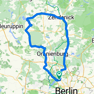
Nordberliner Tour
A cycling route starting in Wittenau, State of Berlin, Germany.
Overview
About this route
Lübars - Hermsdorf - Hohen Neuendorf-Tegel - Wittenau
- -:--
- Duration
- 34.1 km
- Distance
- 121 m
- Ascent
- 120 m
- Descent
- ---
- Avg. speed
- ---
- Max. altitude

Route quality
Waytypes & surfaces along the route
Waytypes
Quiet road
9.9 km
(29 %)
Path
7.5 km
(22 %)
Surfaces
Paved
21.8 km
(64 %)
Unpaved
6.5 km
(19 %)
Asphalt
20.1 km
(59 %)
Loose gravel
2.4 km
(7 %)
Continue with Bikemap
Use, edit, or download this cycling route
You would like to ride Nordberliner Tour or customize it for your own trip? Here is what you can do with this Bikemap route:
Free features
- Save this route as favorite or in collections
- Copy & plan your own version of this route
- Sync your route with Garmin or Wahoo
Premium features
Free trial for 3 days, or one-time payment. More about Bikemap Premium.
- Navigate this route on iOS & Android
- Export a GPX / KML file of this route
- Create your custom printout (try it for free)
- Download this route for offline navigation
Discover more Premium features.
Get Bikemap PremiumFrom our community
Other popular routes starting in Wittenau
 Ab zum Kindergarten
- Distance
- 14.9 km
- Ascent
- 147 m
- Descent
- 135 m
- Location
- Wittenau, State of Berlin, Germany
 FÖV Tour 2016 – Bürgerpark Pankow
- Distance
- 17.5 km
- Ascent
- 18 m
- Descent
- 18 m
- Location
- Wittenau, State of Berlin, Germany
 32 km Trainingstour
- Distance
- 32.8 km
- Ascent
- 76 m
- Descent
- 78 m
- Location
- Wittenau, State of Berlin, Germany
 Wittenau-Waldspielplatz-Ludolfinger-Wittenau
- Distance
- 19.8 km
- Ascent
- 78 m
- Descent
- 75 m
- Location
- Wittenau, State of Berlin, Germany
 43 km Rundtour Henningsdorf, Schönwalde
- Distance
- 41.3 km
- Ascent
- 101 m
- Descent
- 101 m
- Location
- Wittenau, State of Berlin, Germany
 FÖV Tour 2018 – Strandbad Lübars "Kontraste der Großstadt"
- Distance
- 21.4 km
- Ascent
- 96 m
- Descent
- 91 m
- Location
- Wittenau, State of Berlin, Germany
 FÖV Tour 2017 – Botanischer Volkspark Blankenfelde-Pankow
- Distance
- 20.1 km
- Ascent
- 82 m
- Descent
- 82 m
- Location
- Wittenau, State of Berlin, Germany
 beste Rennradstrecke!!!!
- Distance
- 142.4 km
- Ascent
- 149 m
- Descent
- 149 m
- Location
- Wittenau, State of Berlin, Germany
Open it in the app