

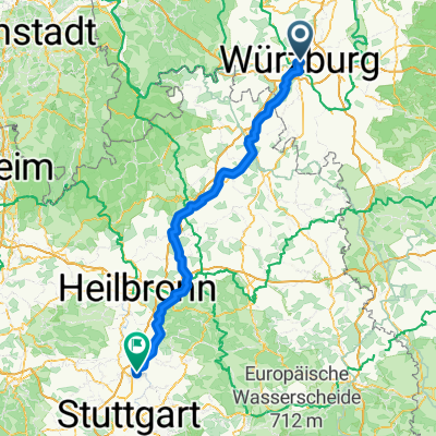
4-Tagestour Würzburg-Heidelberg
A cycling route starting in Würzburg, Bavaria, Germany.
Overview
About this route
1.Würzburg - Werbach
Radweg Romantische Straße
- Werbach-Obernburg
über Radfernweg "liebliches Taubertal" bis Freudenberg
Mainradweg bis Miltenberg
Dreiländerradweg bis Obernburg
- Obernburg-Michelstadt
über Breuberg - Bad König
- Michelstadt - Dilsberg
Hirschhorn
- -:--
- Duration
- 308.8 km
- Distance
- 1,243 m
- Ascent
- 1,305 m
- Descent
- ---
- Avg. speed
- ---
- Max. altitude
Continue with Bikemap
Use, edit, or download this cycling route
You would like to ride 4-Tagestour Würzburg-Heidelberg or customize it for your own trip? Here is what you can do with this Bikemap route:
Free features
- Save this route as favorite or in collections
- Copy & plan your own version of this route
- Split it into stages to create a multi-day tour
- Sync your route with Garmin or Wahoo
Premium features
Free trial for 3 days, or one-time payment. More about Bikemap Premium.
- Navigate this route on iOS & Android
- Export a GPX / KML file of this route
- Create your custom printout (try it for free)
- Download this route for offline navigation
Discover more Premium features.
Get Bikemap PremiumFrom our community
Other popular routes starting in Würzburg
 Ins Welsbachtal
- Distance
- 58.4 km
- Ascent
- 873 m
- Descent
- 827 m
- Location
- Würzburg, Bavaria, Germany
 Wü-Dett-Kt-Och-Eich Och Wü
- Distance
- 77.7 km
- Ascent
- 354 m
- Descent
- 354 m
- Location
- Würzburg, Bavaria, Germany
 Würzburg nach Rothenburg
- Distance
- 77.9 km
- Ascent
- 580 m
- Descent
- 342 m
- Location
- Würzburg, Bavaria, Germany
 Würzburg nach Ludwigsburg Import aus Komoot
- Distance
- 151.2 km
- Ascent
- 1,200 m
- Descent
- 1,177 m
- Location
- Würzburg, Bavaria, Germany
 1-Romantische Straße, Würzburg - Füssen, Teil 1 CLONED FROM ROUTE 181277
- Distance
- 105.7 km
- Ascent
- 476 m
- Descent
- 245 m
- Location
- Würzburg, Bavaria, Germany
 Steinbachtal-H'berg-Waldbüttelbrunn-H'berg-Steinbachtal
- Distance
- 16.9 km
- Ascent
- 239 m
- Descent
- 236 m
- Location
- Würzburg, Bavaria, Germany
 Runde Höhenweg Wü Richtung Och 12xxhm
- Distance
- 56.1 km
- Ascent
- 784 m
- Descent
- 784 m
- Location
- Würzburg, Bavaria, Germany
 Würzburg nach Kochersteinsfeld Import aus Komoot
- Distance
- 96.8 km
- Ascent
- 1,027 m
- Descent
- 1,016 m
- Location
- Würzburg, Bavaria, Germany
Open it in the app