

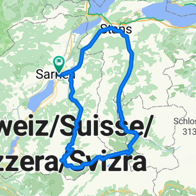
Ächerlipass - Oberrickenbach
A cycling route starting in Sarnen, Canton of Obwalden, Switzerland.
Overview
About this route
Ächerlipass - Oberrickenbach
- -:--
- Duration
- 38.7 km
- Distance
- 1,535 m
- Ascent
- 1,497 m
- Descent
- ---
- Avg. speed
- ---
- Max. altitude
Route quality
Waytypes & surfaces along the route
Waytypes
Quiet road
31 km
(80 %)
Road
2.7 km
(7 %)
Undefined
5 km
(13 %)
Surfaces
Paved
14.7 km
(38 %)
Asphalt
12 km
(31 %)
Paved (undefined)
2.7 km
(7 %)
Undefined
24 km
(62 %)
Continue with Bikemap
Use, edit, or download this cycling route
You would like to ride Ächerlipass - Oberrickenbach or customize it for your own trip? Here is what you can do with this Bikemap route:
Free features
- Save this route as favorite or in collections
- Copy & plan your own version of this route
- Sync your route with Garmin or Wahoo
Premium features
Free trial for 3 days, or one-time payment. More about Bikemap Premium.
- Navigate this route on iOS & Android
- Export a GPX / KML file of this route
- Create your custom printout (try it for free)
- Download this route for offline navigation
Discover more Premium features.
Get Bikemap PremiumFrom our community
Other popular routes starting in Sarnen
 Sportliche Route in Sarnen-Alpnach
- Distance
- 6.3 km
- Ascent
- 245 m
- Descent
- 175 m
- Location
- Sarnen, Canton of Obwalden, Switzerland
 Tour deluxe
- Distance
- 70.3 km
- Ascent
- 2,111 m
- Descent
- 2,110 m
- Location
- Sarnen, Canton of Obwalden, Switzerland
 Sarnen, Ei nach Sarnen, Ei
- Distance
- 19.4 km
- Ascent
- 141 m
- Descent
- 131 m
- Location
- Sarnen, Canton of Obwalden, Switzerland
 Sarnen-Glaubenbühlen-Galubeberg
- Distance
- 82.9 km
- Ascent
- 2,002 m
- Descent
- 2,002 m
- Location
- Sarnen, Canton of Obwalden, Switzerland
 Dorfplatz, Sarnen nach Bahnhofstrasse, Meiringen
- Distance
- 33.7 km
- Ascent
- 803 m
- Descent
- 675 m
- Location
- Sarnen, Canton of Obwalden, Switzerland
 Sarnen - Thun
- Distance
- 73.5 km
- Ascent
- 1,328 m
- Descent
- 1,234 m
- Location
- Sarnen, Canton of Obwalden, Switzerland
 Seestrasse 20, Sarnen nach Flecken 11, Rothenburg
- Distance
- 53.6 km
- Ascent
- 2,182 m
- Descent
- 2,164 m
- Location
- Sarnen, Canton of Obwalden, Switzerland
 Sarnersee-Giswil-FlüeliRanft
- Distance
- 33.5 km
- Ascent
- 795 m
- Descent
- 792 m
- Location
- Sarnen, Canton of Obwalden, Switzerland
Open it in the app