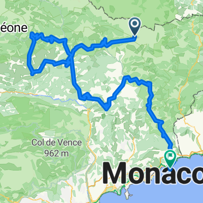
08. Etappe "Route des Grandes Alpes"
A cycling route starting in Saint-Martin-V茅subie, Provence-Alpes-C么te d'Azur Region, France.
Overview
About this route
Start: Valdeblore
Finish: Menton
Passes: Col Saint Martin; Col de Turini, Col de Castillon
- -:--
- Duration
- 86.6 km
- Distance
- 1,881 m
- Ascent
- 2,877 m
- Descent
- ---
- Avg. speed
- ---
- Max. altitude
Continue with Bikemap
Use, edit, or download this cycling route
You would like to ride 08. Etappe "Route des Grandes Alpes" or customize it for your own trip? Here is what you can do with this Bikemap route:
Free features
- Save this route as favorite or in collections
- Copy & plan your own version of this route
- Split it into stages to create a multi-day tour
- Sync your route with Garmin or Wahoo
Premium features
Free trial for 3 days, or one-time payment. More about Bikemap Premium.
- Navigate this route on iOS & Android
- Export a GPX / KML file of this route
- Create your custom printout (try it for free)
- Download this route for offline navigation
Discover more Premium features.
Get Bikemap PremiumFrom our community
Other popular routes starting in Saint-Martin-V茅subie
016 - 2014- Distance
- 73.1 km
- Ascent
- 2,427 m
- Descent
- 489 m
- Location
- Saint-Martin-V茅subie, Provence-Alpes-C么te d'Azur Region, France
MS 11b, Valdeblore - San Remo - MS 11b, Valdeblore - San Remo- Distance
- 137.3 km
- Ascent
- 2,617 m
- Descent
- 3,589 m
- Location
- Saint-Martin-V茅subie, Provence-Alpes-C么te d'Azur Region, France
2012-08-17 Saint Martin Vesubie-Duranus-Nice-Menton-Late (It.)- Distance
- 96.6 km
- Ascent
- 842 m
- Descent
- 1,739 m
- Location
- Saint-Martin-V茅subie, Provence-Alpes-C么te d'Azur Region, France
MS 11a, Valdeblore - San Remo - MS 11a, Valdeblore - San Remo- Distance
- 131.7 km
- Ascent
- 2,519 m
- Descent
- 3,495 m
- Location
- Saint-Martin-V茅subie, Provence-Alpes-C么te d'Azur Region, France
Recording from 19 septembre 09:08- Distance
- 27.1 km
- Ascent
- 1,005 m
- Descent
- 1,006 m
- Location
- Saint-Martin-V茅subie, Provence-Alpes-C么te d'Azur Region, France
2013 09 12 COG Roure-Colomars- Distance
- 62.3 km
- Ascent
- 518 m
- Descent
- 1,308 m
- Location
- Saint-Martin-V茅subie, Provence-Alpes-C么te d'Azur Region, France
Bonette route: St saveur de Tinee - La Bonette (2802 m) - Jausiers- Distance
- 77.3 km
- Ascent
- 2,242 m
- Descent
- 1,572 m
- Location
- Saint-Martin-V茅subie, Provence-Alpes-C么te d'Azur Region, France
Dalle Alpi al Mont Ventoux: Giorno 2: Roure - Castellane- Distance
- 104.7 km
- Ascent
- 1,736 m
- Descent
- 2,105 m
- Location
- Saint-Martin-V茅subie, Provence-Alpes-C么te d'Azur Region, France
Open it in the app

