

Adlwang - Waldneukirchen (Ortszentren, Umgehung von Hauptverkehrsstraßen)
A cycling route starting in Waldneukirchen, Upper Austria, Austria.
Overview
About this route
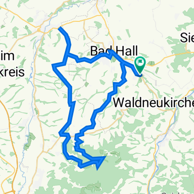
Vom Adlwanger Ortszentrum aus führt der Weg nach Osten über die Waldneukirchner Straße. Dieser folgt man etwa 2 km, wobei man den Fernbach überquert, und nach dem darauffolgenden Anstieg biegt man an einer Kreuzung rechts auf die Bergstraße ab. Nach etwas weniger als einem km muss man sich an einer Gabelung links halten, fährt dann recht steil bergab, und biegt kurz vor der Hauptstraße L556 rechts ab auf die Teichstraße. Auf dieser erreicht man nach einem kurzen Anstieg das Ortszentrum.
Dauer: etwa 15 Minuten- -:--
- Duration
- 3.7 km
- Distance
- 64 m
- Ascent
- 47 m
- Descent
- ---
- Avg. speed
- ---
- Avg. speed
Route quality
Waytypes & surfaces along the route
Waytypes
Quiet road
1.8 km
(48 %)
Busy road
1.7 km
(45 %)
Surfaces
Paved
1.7 km
(47 %)
Asphalt
1.7 km
(47 %)
Undefined
2 km
(53 %)
Continue with Bikemap
Use, edit, or download this cycling route
You would like to ride Adlwang - Waldneukirchen (Ortszentren, Umgehung von Hauptverkehrsstraßen) or customize it for your own trip? Here is what you can do with this Bikemap route:
Free features
- Save this route as favorite or in collections
- Copy & plan your own version of this route
- Sync your route with Garmin or Wahoo
Premium features
Free trial for 3 days, or one-time payment. More about Bikemap Premium.
- Navigate this route on iOS & Android
- Export a GPX / KML file of this route
- Create your custom printout (try it for free)
- Download this route for offline navigation
Discover more Premium features.
Get Bikemap PremiumFrom our community
Other popular routes starting in Waldneukirchen
 Waldneukirchen - Bad Hall (Ortszentren, Umgehung von Hauptverkehrsstraßen)
- Distance
- 6.2 km
- Ascent
- 28 m
- Descent
- 89 m
- Location
- Waldneukirchen, Upper Austria, Austria
 Etappe9
- Distance
- 21.6 km
- Ascent
- 159 m
- Descent
- 266 m
- Location
- Waldneukirchen, Upper Austria, Austria
 Waldneukirchen - Untergrünburg (Ortszentren, Umgehung von Hauptverkehrsstraßen)
- Distance
- 4.3 km
- Ascent
- 26 m
- Descent
- 105 m
- Location
- Waldneukirchen, Upper Austria, Austria
 2023_11_04_Bad Haller-Auf´s Weiss´n
- Distance
- 44 km
- Ascent
- 742 m
- Descent
- 741 m
- Location
- Waldneukirchen, Upper Austria, Austria
 2023_10_21_Bad Haller-Tassilorunde
- Distance
- 52.8 km
- Ascent
- 616 m
- Descent
- 616 m
- Location
- Waldneukirchen, Upper Austria, Austria
 Waldneukirchen - Salzburg - Waldneukirchen
- Distance
- 245 km
- Ascent
- 1,078 m
- Descent
- 1,078 m
- Location
- Waldneukirchen, Upper Austria, Austria
 Grünburg Trattenbach Grünburgerhütte
- Distance
- 55.9 km
- Ascent
- 1,536 m
- Descent
- 1,536 m
- Location
- Waldneukirchen, Upper Austria, Austria
 Adlwang - Waldneukirchen (Ortszentren, Umgehung von Hauptverkehrsstraßen)
- Distance
- 3.7 km
- Ascent
- 64 m
- Descent
- 47 m
- Location
- Waldneukirchen, Upper Austria, Austria
Open it in the app