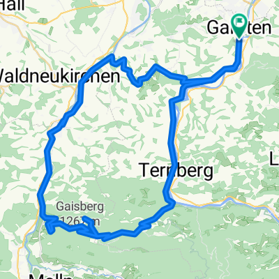
Steyrtalrunde
- 97 km
- 895 m
- 893 m
- Garsten, Upper Austria, Austria
A cycling route starting in Garsten, Upper Austria, Austria.
Overview
To get out of the village, leave Am Platzl and turn left (west) onto the L1344, following this road past the prison and then turning right into Klosterstraße, passing under the railway. Next, turn left onto Höllstraße and then at the first junction turn right onto Windnerstraße. Follow its course at the next intersection, at the next fork keep to the right and cross the Teufelsbach. Now head up Laichbergweg, turning left after the next settlement, then follow the right curve and keep left, crossing Sandbauernstraße diagonally to the left. Now follow Guggerlehnerstraße by turning left once and right twice, after which you will cross Hofergrabenbach. After about 1 km, turn left onto Aschacher Straße, which must be left again after less than a hundred meters by turning right onto Reitnerstraße. This soon becomes Christkindlstraße and later Tinstinger Straße. The latter should be followed through Tinsting and Schwaming to the Steyr crossing at Letten for about 4 km. Then go up Lettenstraße. At Steyrtalstraße, briefly turn left, then immediately right onto Wetzendorfstraße, which then turns into Frauenhofenstraße, where you go under the B122. Then follow Bahnhofstraße into the center of Sierning (this cannot be represented here in the last section). Duration: 40-45 minutes
created this 10 years ago
Route quality
Quiet road
8.5 km
(75 %)
Road
2.7 km
(24 %)
Paved
9.2 km
(81 %)
Unpaved
0.1 km
(1 %)
Asphalt
9.2 km
(81 %)
Gravel
0.1 km
(1 %)
Undefined
2 km
(18 %)
Continue with Bikemap
You would like to ride Garsten - Sierning (Ortszentren, Umgehung von Hauptverkehrsstraßen) or customize it for your own trip? Here is what you can do with this Bikemap route:
Free trial for 3 days, or one-time payment. More about Bikemap Premium.
Discover more Premium features.
Get Bikemap PremiumFrom our community
Open it in the app