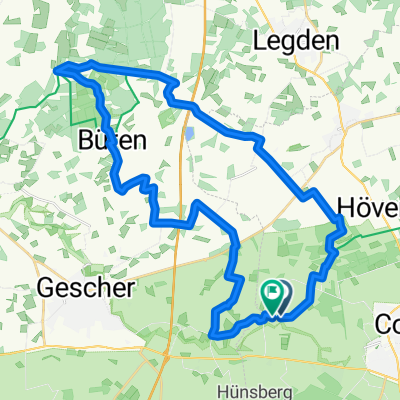
Heide 25.08.13
A cycling route starting in Coesfeld, North Rhine-Westphalia, Germany.
Overview
About this route
25.08.13 15:30 (cloned from route 2304682)
(cloned from route 3028554)
- -:--
- Duration
- 22.2 km
- Distance
- 97 m
- Ascent
- 95 m
- Descent
- ---
- Avg. speed
- ---
- Max. altitude
Route quality
Waytypes & surfaces along the route
Waytypes
Track
9.6 km
(43 %)
Path
6.4 km
(29 %)
Surfaces
Paved
2.4 km
(11 %)
Unpaved
12.9 km
(58 %)
Gravel
4.7 km
(21 %)
Ground
3.8 km
(17 %)
Continue with Bikemap
Use, edit, or download this cycling route
You would like to ride Heide 25.08.13 or customize it for your own trip? Here is what you can do with this Bikemap route:
Free features
- Save this route as favorite or in collections
- Copy & plan your own version of this route
- Sync your route with Garmin or Wahoo
Premium features
Free trial for 3 days, or one-time payment. More about Bikemap Premium.
- Navigate this route on iOS & Android
- Export a GPX / KML file of this route
- Create your custom printout (try it for free)
- Download this route for offline navigation
Discover more Premium features.
Get Bikemap PremiumFrom our community
Other popular routes starting in Coesfeld
KREUZWEG TOUR- Distance
- 15.5 km
- Ascent
- 48 m
- Descent
- 46 m
- Location
- Coesfeld, North Rhine-Westphalia, Germany
EV 2 Coesfeld - Münster- Distance
- 54.5 km
- Ascent
- 130 m
- Descent
- 154 m
- Location
- Coesfeld, North Rhine-Westphalia, Germany
Goxel-Gaststätte Rappers- Distance
- 12.9 km
- Ascent
- 43 m
- Descent
- 54 m
- Location
- Coesfeld, North Rhine-Westphalia, Germany
Goxel-Waldfrieden- Distance
- 17.5 km
- Ascent
- 79 m
- Descent
- 101 m
- Location
- Coesfeld, North Rhine-Westphalia, Germany
Markt nach Am Roten Baum- Distance
- 19.5 km
- Ascent
- 65 m
- Descent
- 104 m
- Location
- Coesfeld, North Rhine-Westphalia, Germany
Sägewerk - Gut Ross, Tour von GPSies 42 km- Distance
- 41.8 km
- Ascent
- 63 m
- Descent
- 61 m
- Location
- Coesfeld, North Rhine-Westphalia, Germany
RTF Coesfeld 112km 2009- Distance
- 115.5 km
- Ascent
- 500 m
- Descent
- 490 m
- Location
- Coesfeld, North Rhine-Westphalia, Germany
D101-Baumberger-Sandsteinroute-172km- Distance
- 175.1 km
- Ascent
- 408 m
- Descent
- 410 m
- Location
- Coesfeld, North Rhine-Westphalia, Germany
Open it in the app

