

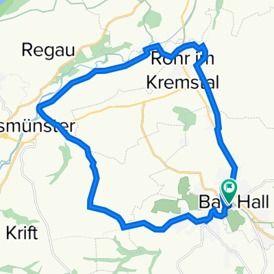
Rohr im Kremstal - Kremsmünster (Ortszentren, Umgehung von Hauptverkehrsstraßen)
A cycling route starting in Bad Hall, Upper Austria, Austria.
Overview
About this route
<p>From the village center, head west and turn right onto Achleitner Street. This goes underneath the railway embankment and subsequently crosses the Steinbach, after which you turn left into the Au. From here, you can easily follow the Kremstalradweg R12 to the center of Kremsmünster.</p>
<p>Duration: 10-15 minutes</p>
Translated, show original (German)- -:--
- Duration
- 6.2 km
- Distance
- 24 m
- Ascent
- 9 m
- Descent
- ---
- Avg. speed
- ---
- Max. altitude
Route quality
Waytypes & surfaces along the route
Waytypes
Quiet road
6.1 km
(99 %)
Undefined
0.1 km
(1 %)
Continue with Bikemap
Use, edit, or download this cycling route
You would like to ride Rohr im Kremstal - Kremsmünster (Ortszentren, Umgehung von Hauptverkehrsstraßen) or customize it for your own trip? Here is what you can do with this Bikemap route:
Free features
- Save this route as favorite or in collections
- Copy & plan your own version of this route
- Sync your route with Garmin or Wahoo
Premium features
Free trial for 3 days, or one-time payment. More about Bikemap Premium.
- Navigate this route on iOS & Android
- Export a GPX / KML file of this route
- Create your custom printout (try it for free)
- Download this route for offline navigation
Discover more Premium features.
Get Bikemap PremiumFrom our community
Other popular routes starting in Bad Hall
 Bad Hall - Enns
- Distance
- 67.5 km
- Ascent
- 632 m
- Descent
- 746 m
- Location
- Bad Hall, Upper Austria, Austria
 Kultur in Bad Hall
- Distance
- 18.7 km
- Ascent
- 204 m
- Descent
- 205 m
- Location
- Bad Hall, Upper Austria, Austria
 2025_05_21_Rohr-Traunbrücke-Kematen-Rohr
- Distance
- 50.1 km
- Ascent
- 535 m
- Descent
- 533 m
- Location
- Bad Hall, Upper Austria, Austria
 5 Flüsse Runde
- Distance
- 105.6 km
- Ascent
- 432 m
- Descent
- 426 m
- Location
- Bad Hall, Upper Austria, Austria
 Hintergebirge Goashansl Runde
- Distance
- 82.9 km
- Ascent
- 1,053 m
- Descent
- 1,051 m
- Location
- Bad Hall, Upper Austria, Austria
 Rohr Runde
- Distance
- 7.3 km
- Ascent
- 164 m
- Descent
- 174 m
- Location
- Bad Hall, Upper Austria, Austria
 353 Mostradler 19
- Distance
- 19.4 km
- Ascent
- 170 m
- Descent
- 170 m
- Location
- Bad Hall, Upper Austria, Austria
 Bad Hall - Design Center
- Distance
- 37.3 km
- Ascent
- 94 m
- Descent
- 217 m
- Location
- Bad Hall, Upper Austria, Austria
Open it in the app