

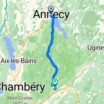
Le Semnoz
A cycling route starting in Annecy, Auvergne-Rhône-Alpes, France.
Overview
About this route
An alternate, partially unpaved route up Le Semnoz: Annecy's highest cycling climb.
- -:--
- Duration
- 56.9 km
- Distance
- 1,255 m
- Ascent
- 1,255 m
- Descent
- ---
- Avg. speed
- ---
- Max. altitude

Route quality
Waytypes & surfaces along the route
Waytypes
Track
15.4 km
(27 %)
Cycleway
3.4 km
(6 %)
Surfaces
Paved
45.5 km
(80 %)
Unpaved
9.1 km
(16 %)
Asphalt
44.4 km
(78 %)
Gravel
6.3 km
(11 %)
Route highlights
Points of interest along the route
Point of interest after 24.1 km
Highpoint Paved road
Point of interest after 28.2 km
Le Golet Rond
Point of interest after 42 km
Col de Leschaux
Continue with Bikemap
Use, edit, or download this cycling route
You would like to ride Le Semnoz or customize it for your own trip? Here is what you can do with this Bikemap route:
Free features
- Save this route as favorite or in collections
- Copy & plan your own version of this route
- Sync your route with Garmin or Wahoo
Premium features
Free trial for 3 days, or one-time payment. More about Bikemap Premium.
- Navigate this route on iOS & Android
- Export a GPX / KML file of this route
- Create your custom printout (try it for free)
- Download this route for offline navigation
Discover more Premium features.
Get Bikemap PremiumFrom our community
Other popular routes starting in Annecy
 FORCLAZ MONTMIN VERSANT SUD 31MAI 2014
- Distance
- 54.5 km
- Ascent
- 757 m
- Descent
- 759 m
- Location
- Annecy, Auvergne-Rhône-Alpes, France
 Annecy Loop 130km / 2800hm
- Distance
- 129.8 km
- Ascent
- 2,456 m
- Descent
- 2,455 m
- Location
- Annecy, Auvergne-Rhône-Alpes, France
 Day 1 - Annecy to Montgilbert
- Distance
- 60.9 km
- Ascent
- 767 m
- Descent
- 678 m
- Location
- Annecy, Auvergne-Rhône-Alpes, France
 Col du Colombiere
- Distance
- 122.8 km
- Ascent
- 1,982 m
- Descent
- 1,982 m
- Location
- Annecy, Auvergne-Rhône-Alpes, France
 2023_Frankring_Lac d'Annecy Cycle Path
- Distance
- 38.2 km
- Ascent
- 321 m
- Descent
- 321 m
- Location
- Annecy, Auvergne-Rhône-Alpes, France
 02 Annecy-Moûtiers
- Distance
- 70.8 km
- Ascent
- 294 m
- Descent
- 268 m
- Location
- Annecy, Auvergne-Rhône-Alpes, France
 Col de la Madeleine
- Distance
- 121.5 km
- Ascent
- 1,903 m
- Descent
- 1,818 m
- Location
- Annecy, Auvergne-Rhône-Alpes, France
 Almenroute
- Distance
- 52.9 km
- Ascent
- 901 m
- Descent
- 992 m
- Location
- Annecy, Auvergne-Rhône-Alpes, France
Open it in the app