

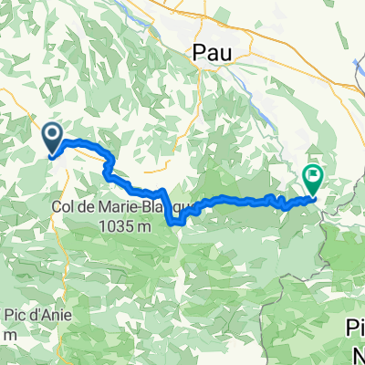
etapa 6 - R
A cycling route starting in Oloron-Sainte-Marie, Nouvelle-Aquitaine, France.
Overview
About this route
- -:--
- Duration
- 107.8 km
- Distance
- 2,550 m
- Ascent
- 2,136 m
- Descent
- ---
- Avg. speed
- ---
- Max. altitude

Route quality
Waytypes & surfaces along the route
Waytypes
Road
11.9 km
(11 %)
Undefined
95.9 km
(89 %)
Surfaces
Paved
43.1 km
(40 %)
Asphalt
43.1 km
(40 %)
Undefined
64.7 km
(60 %)
Route highlights
Points of interest along the route
Point of interest after 35.3 km
Col de Labays
Point of interest after 39 km
Col du Soudet
Point of interest after 43.3 km
Col de la Pierre-Siant-Martin
Point of interest after 81.8 km
?
Point of interest after 95.7 km
Port de Larrau
Continue with Bikemap
Use, edit, or download this cycling route
You would like to ride etapa 6 - R or customize it for your own trip? Here is what you can do with this Bikemap route:
Free features
- Save this route as favorite or in collections
- Copy & plan your own version of this route
- Split it into stages to create a multi-day tour
- Sync your route with Garmin or Wahoo
Premium features
Free trial for 3 days, or one-time payment. More about Bikemap Premium.
- Navigate this route on iOS & Android
- Export a GPX / KML file of this route
- Create your custom printout (try it for free)
- Download this route for offline navigation
Discover more Premium features.
Get Bikemap PremiumFrom our community
Other popular routes starting in Oloron-Sainte-Marie
 Chemin de la Gravette to Rue les Justices
- Distance
- 50 km
- Ascent
- 801 m
- Descent
- 775 m
- Location
- Oloron-Sainte-Marie, Nouvelle-Aquitaine, France
 Col Marie Blanque and Col d'Aubisque
- Distance
- 110.3 km
- Ascent
- 2,130 m
- Descent
- 2,137 m
- Location
- Oloron-Sainte-Marie, Nouvelle-Aquitaine, France
 Oloron - Oloron
- Distance
- 103.2 km
- Ascent
- 1,944 m
- Descent
- 1,940 m
- Location
- Oloron-Sainte-Marie, Nouvelle-Aquitaine, France
 2016 Ride Day 46 - Oloron-Ste-Marie to Argelès-Gazost (Arcizans-Avant)
- Distance
- 81.3 km
- Ascent
- 729 m
- Descent
- 397 m
- Location
- Oloron-Sainte-Marie, Nouvelle-Aquitaine, France
 Cycle to Spain - Day 11 - 2004/15
- Distance
- 155.9 km
- Ascent
- 323 m
- Descent
- 537 m
- Location
- Oloron-Sainte-Marie, Nouvelle-Aquitaine, France
 jean pied via lourdes en carcasson naar Narbonne
- Distance
- 72.3 km
- Ascent
- 1,527 m
- Descent
- 1,355 m
- Location
- Oloron-Sainte-Marie, Nouvelle-Aquitaine, France
 Chemin de la Gravette to Saillet
- Distance
- 53.3 km
- Ascent
- 828 m
- Descent
- 765 m
- Location
- Oloron-Sainte-Marie, Nouvelle-Aquitaine, France
 *X-11. Oloron-Sainte-Marie - Val Louron (181,5 Km)
- Distance
- 181.5 km
- Ascent
- 5,484 m
- Descent
- 4,266 m
- Location
- Oloron-Sainte-Marie, Nouvelle-Aquitaine, France
Open it in the app