

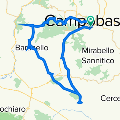
Sali scendi da Campobasso-Limosano-Sant'Angelo Limosano
A cycling route starting in Campobasso, Molise, Italy.
Overview
About this route
Medium difficulty route. It develops on paved roads up to the village of Sant'Angelo Limosano, from Sant'Angelo Limosano to the village of Fossalto, you pedal downhill on a stretch of road with various landslides with a dirty gravel road. Once you reach the valley floor, you pedal on asphalt.
- -:--
- Duration
- 57.2 km
- Distance
- 1,000 m
- Ascent
- 992 m
- Descent
- ---
- Avg. speed
- ---
- Max. altitude
Route quality
Waytypes & surfaces along the route
Waytypes
Road
19.5 km
(34 %)
Quiet road
4 km
(7 %)
Surfaces
Paved
3.4 km
(6 %)
Asphalt
3.4 km
(6 %)
Undefined
53.8 km
(94 %)
Continue with Bikemap
Use, edit, or download this cycling route
You would like to ride Sali scendi da Campobasso-Limosano-Sant'Angelo Limosano or customize it for your own trip? Here is what you can do with this Bikemap route:
Free features
- Save this route as favorite or in collections
- Copy & plan your own version of this route
- Sync your route with Garmin or Wahoo
Premium features
Free trial for 3 days, or one-time payment. More about Bikemap Premium.
- Navigate this route on iOS & Android
- Export a GPX / KML file of this route
- Create your custom printout (try it for free)
- Download this route for offline navigation
Discover more Premium features.
Get Bikemap PremiumFrom our community
Other popular routes starting in Campobasso
 Itinerario Domenica 20 Luglio 2014 test Granfondo del Matese
- Distance
- 194.8 km
- Ascent
- 2,439 m
- Descent
- 2,708 m
- Location
- Campobasso, Molise, Italy
 campobasso-oratino-montagano-campobasso
- Distance
- 56.8 km
- Ascent
- 875 m
- Descent
- 902 m
- Location
- Campobasso, Molise, Italy
 Campobasso - Busso - Monte Vairano
- Distance
- 26.8 km
- Ascent
- 567 m
- Descent
- 572 m
- Location
- Campobasso, Molise, Italy
 Test 10
- Distance
- 44.9 km
- Ascent
- 1,175 m
- Descent
- 1,173 m
- Location
- Campobasso, Molise, Italy
 Giro panoramico per paesi.
- Distance
- 57.6 km
- Ascent
- 982 m
- Descent
- 980 m
- Location
- Campobasso, Molise, Italy
 Bosco Faiete e Castello Monforte
- Distance
- 16.3 km
- Ascent
- 494 m
- Descent
- 398 m
- Location
- Campobasso, Molise, Italy
 Campobasso-Tappino
- Distance
- 8.8 km
- Ascent
- 215 m
- Descent
- 211 m
- Location
- Campobasso, Molise, Italy
 Campobasso - Benevento
- Distance
- 66.4 km
- Ascent
- 841 m
- Descent
- 1,398 m
- Location
- Campobasso, Molise, Italy
Open it in the app