

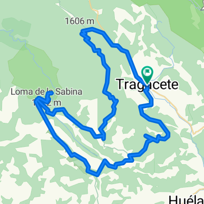
Rodeando la Mogorrita. La Losilla.
A cycling route starting in Huélamo, Castille-La Mancha, Spain.
Overview
About this route
Route around the Cerro de la Mogorrita, with incredible views from La Losilla towards the Barranco del Hontanar.
- -:--
- Duration
- 35.8 km
- Distance
- 802 m
- Ascent
- 803 m
- Descent
- ---
- Avg. speed
- ---
- Max. altitude
Route highlights
Points of interest along the route
Point of interest after 13.6 km
Valtablado
Photo after 22.7 km
Nos adentramos en el monte, campo a través hasta la Cañada mediana.
Point of interest after 23.5 km
Cañada Mediana

Photo after 26.3 km
Vistas desde la losilla
Point of interest after 29 km
Albergue de San Blas.
Drinking water after 29.2 km
Cascada.
Continue with Bikemap
Use, edit, or download this cycling route
You would like to ride Rodeando la Mogorrita. La Losilla. or customize it for your own trip? Here is what you can do with this Bikemap route:
Free features
- Save this route as favorite or in collections
- Copy & plan your own version of this route
- Sync your route with Garmin or Wahoo
Premium features
Free trial for 3 days, or one-time payment. More about Bikemap Premium.
- Navigate this route on iOS & Android
- Export a GPX / KML file of this route
- Create your custom printout (try it for free)
- Download this route for offline navigation
Discover more Premium features.
Get Bikemap PremiumFrom our community
Other popular routes starting in Huélamo
 Propuesta Cobardes 2020 - Día 3
- Distance
- 56.1 km
- Ascent
- 2,294 m
- Descent
- 2,294 m
- Location
- Huélamo, Castille-La Mancha, Spain
 Rodeando la Mogorrita. La Losilla.
- Distance
- 35.8 km
- Ascent
- 802 m
- Descent
- 803 m
- Location
- Huélamo, Castille-La Mancha, Spain
 Tragacete_Osquillo_La Bandera
- Distance
- 51.3 km
- Ascent
- 1,079 m
- Descent
- 1,079 m
- Location
- Huélamo, Castille-La Mancha, Spain
 Tragacete_NacimientoJucar_NacimientoCuervo
- Distance
- 30.3 km
- Ascent
- 697 m
- Descent
- 748 m
- Location
- Huélamo, Castille-La Mancha, Spain
 Herrería de los Chorros
- Distance
- 45.2 km
- Ascent
- 936 m
- Descent
- 936 m
- Location
- Huélamo, Castille-La Mancha, Spain
 Etapa 4.-Tragacete-Albarracín
- Distance
- 56.4 km
- Ascent
- 687 m
- Descent
- 862 m
- Location
- Huélamo, Castille-La Mancha, Spain
 Ruta 36 : Serrania de Cuenca ruta 2
- Distance
- 77 km
- Ascent
- 871 m
- Descent
- 1,289 m
- Location
- Huélamo, Castille-La Mancha, Spain
 enterita 1
- Distance
- 314.2 km
- Ascent
- 2,492 m
- Descent
- 2,452 m
- Location
- Huélamo, Castille-La Mancha, Spain
Open it in the app