

20150726_122206.gpx
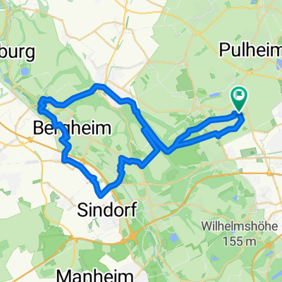
A cycling route starting in Pulheim, North Rhine-Westphalia, Germany.
Overview
About this route
TEASI track
- -:--
- Duration
- 18.4 km
- Distance
- 41 m
- Ascent
- 42 m
- Descent
- ---
- Avg. speed
- ---
- Max. altitude
Continue with Bikemap
Use, edit, or download this cycling route
You would like to ride 20150726_122206.gpx or customize it for your own trip? Here is what you can do with this Bikemap route:
Free features
- Save this route as favorite or in collections
- Copy & plan your own version of this route
- Sync your route with Garmin or Wahoo
Premium features
Free trial for 3 days, or one-time payment. More about Bikemap Premium.
- Navigate this route on iOS & Android
- Export a GPX / KML file of this route
- Create your custom printout (try it for free)
- Download this route for offline navigation
Discover more Premium features.
Get Bikemap PremiumFrom our community
Other popular routes starting in Pulheim
 PSC-RTF Strecke 74km
- Distance
- 72.3 km
- Ascent
- 218 m
- Descent
- 189 m
- Location
- Pulheim, North Rhine-Westphalia, Germany
 105. Frühschoppentour
- Distance
- 47.2 km
- Ascent
- 92 m
- Descent
- 92 m
- Location
- Pulheim, North Rhine-Westphalia, Germany
 Bergheimer_Acht südwest
- Distance
- 42.2 km
- Ascent
- 271 m
- Descent
- 268 m
- Location
- Pulheim, North Rhine-Westphalia, Germany
 Runde Pulheim-Neurath BOA
- Distance
- 39.2 km
- Ascent
- 167 m
- Descent
- 140 m
- Location
- Pulheim, North Rhine-Westphalia, Germany
 Glessener Höhe 1 (MTB)
- Distance
- 20.1 km
- Ascent
- 213 m
- Descent
- 215 m
- Location
- Pulheim, North Rhine-Westphalia, Germany
 Meine Feierabend-Runde
- Distance
- 45.8 km
- Ascent
- 70 m
- Descent
- 78 m
- Location
- Pulheim, North Rhine-Westphalia, Germany
 Wochenend Runde fürs Rennrad
- Distance
- 60.9 km
- Ascent
- 95 m
- Descent
- 93 m
- Location
- Pulheim, North Rhine-Westphalia, Germany
 Pul-Sto-StoBu-Knechtst-Sdf-Pul
- Distance
- 27.2 km
- Ascent
- 47 m
- Descent
- 50 m
- Location
- Pulheim, North Rhine-Westphalia, Germany
Open it in the app