

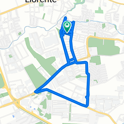
Vuelta CR 2015: Etapa 11
A cycling route starting in Llorente, Heredia Province, Costa Rica.
Overview
About this route
Circuito Presidente
- -:--
- Duration
- 9.8 km
- Distance
- 149 m
- Ascent
- 149 m
- Descent
- ---
- Avg. speed
- ---
- Max. altitude
Route quality
Waytypes & surfaces along the route
Waytypes
Quiet road
1.5 km
(15 %)
Access road
0.8 km
(8 %)
Undefined
7.5 km
(77 %)
Surfaces
Paved
8.6 km
(88 %)
Asphalt
8.5 km
(87 %)
Paved (undefined)
0.1 km
(1 %)
Undefined
1.2 km
(12 %)
Continue with Bikemap
Use, edit, or download this cycling route
You would like to ride Vuelta CR 2015: Etapa 11 or customize it for your own trip? Here is what you can do with this Bikemap route:
Free features
- Save this route as favorite or in collections
- Copy & plan your own version of this route
- Sync your route with Garmin or Wahoo
Premium features
Free trial for 3 days, or one-time payment. More about Bikemap Premium.
- Navigate this route on iOS & Android
- Export a GPX / KML file of this route
- Create your custom printout (try it for free)
- Download this route for offline navigation
Discover more Premium features.
Get Bikemap PremiumFrom our community
Other popular routes starting in Llorente
 Heredia to XVQ2+C24, Heredia
- Distance
- 11.3 km
- Ascent
- 200 m
- Descent
- 197 m
- Location
- Llorente, Heredia Province, Costa Rica
 Calle José Muñoz, San José a Calle José Muñoz, San José
- Distance
- 29.6 km
- Ascent
- 820 m
- Descent
- 824 m
- Location
- Llorente, Heredia Province, Costa Rica
 Paseo lento en San José
- Distance
- 11.1 km
- Ascent
- 142 m
- Descent
- 148 m
- Location
- Llorente, Heredia Province, Costa Rica
 Ride Flores-Guacima-Piedras Negras-Ciudad Colon-Belen-Flores
- Distance
- 64.7 km
- Ascent
- 841 m
- Descent
- 841 m
- Location
- Llorente, Heredia Province, Costa Rica
 Un viaje increíble
- Distance
- 6.2 km
- Ascent
- 149 m
- Descent
- 153 m
- Location
- Llorente, Heredia Province, Costa Rica
 De Calle José Muñoz, San José a Calle José Muñoz, San José
- Distance
- 22.9 km
- Ascent
- 132 m
- Descent
- 132 m
- Location
- Llorente, Heredia Province, Costa Rica
 Cenada-Tibas
- Distance
- 11 km
- Ascent
- 249 m
- Descent
- 99 m
- Location
- Llorente, Heredia Province, Costa Rica
 Ruta Warren ----- Una matada de 80 kms
- Distance
- 83.3 km
- Ascent
- 1,047 m
- Descent
- 1,042 m
- Location
- Llorente, Heredia Province, Costa Rica
Open it in the app