

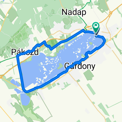
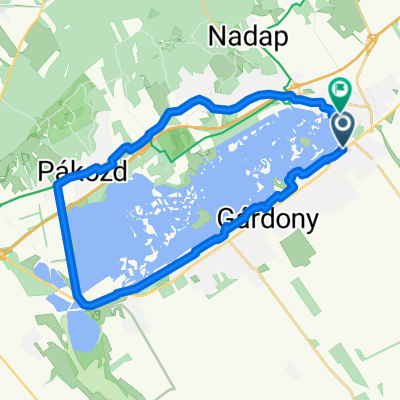
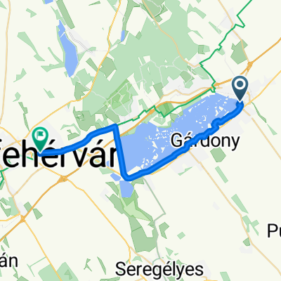
Velencei-tó/Lake Velence
A cycling route starting in Velence, Fejér, Hungary.
Overview
About this route
Kényelmes tempóban kb. 65-70 perc alatt körbetekerhető a tó MTB-kal. 28.5 km hosszú, végig műút: Velence - Velencefürdő - Gárdony - Agárd - Pákozd - Sukoró - Velence. Út közben vannak nyilvános kutak, ahol vízvételi lehetőség van. Pákozd - Sukoró között van egy-két emelkedő, de nem meredek egyik sem. Az útvonal nem a kerékpárutat követi, mert az kacskaringósabb, hanem a műúton halad.
At a convenient pace it is a 65-70-minute-ride around the lake by MTB. Approximately, 28.5 km long, all the way tarmac surface: Velence - Velencefürdő - Gárdony - Agárd - Pákozd - Sukoró - Velence. There are several public water wells on the way. There are some modest ascents between Pákozd - Sukoró, none of them steep though. The route follows the motorway, not the bikeroad, which is too windy, sinuous.- -:--
- Duration
- 27 km
- Distance
- 74 m
- Ascent
- 74 m
- Descent
- ---
- Avg. speed
- ---
- Max. altitude

Route quality
Waytypes & surfaces along the route
Waytypes
Quiet road
9.2 km
(34 %)
Cycleway
7.8 km
(29 %)
Surfaces
Paved
24 km
(89 %)
Asphalt
24 km
(89 %)
Undefined
3 km
(11 %)
Continue with Bikemap
Use, edit, or download this cycling route
You would like to ride Velencei-tó/Lake Velence or customize it for your own trip? Here is what you can do with this Bikemap route:
Free features
- Save this route as favorite or in collections
- Copy & plan your own version of this route
- Sync your route with Garmin or Wahoo
Premium features
Free trial for 3 days, or one-time payment. More about Bikemap Premium.
- Navigate this route on iOS & Android
- Export a GPX / KML file of this route
- Create your custom printout (try it for free)
- Download this route for offline navigation
Discover more Premium features.
Get Bikemap PremiumFrom our community
Other popular routes starting in Velence
 Velencei tó 2025.11.01. új bringa
- Distance
- 29.4 km
- Ascent
- 74 m
- Descent
- 121 m
- Location
- Velence, Fejér, Hungary
 Enyedi utca, Velence - Enyedi utca, Velence
- Distance
- 57.9 km
- Ascent
- 170 m
- Descent
- 169 m
- Location
- Velence, Fejér, Hungary
 Tópart utca, Velence - Dolovai sor, Székesfehérvár
- Distance
- 24.3 km
- Ascent
- 80 m
- Descent
- 47 m
- Location
- Velence, Fejér, Hungary
 Panoráma út - Evezős út
- Distance
- 32.8 km
- Ascent
- 63 m
- Descent
- 134 m
- Location
- Velence, Fejér, Hungary
 Velence Béke utca - Velence Tó utca
- Distance
- 28.4 km
- Ascent
- 127 m
- Descent
- 175 m
- Location
- Velence, Fejér, Hungary
 Velence - Dolovai sor, Székesfehérvár
- Distance
- 23.9 km
- Ascent
- 69 m
- Descent
- 34 m
- Location
- Velence, Fejér, Hungary
 Radnóti utca, Velence - Radnóti utca, Velence
- Distance
- 31.7 km
- Ascent
- 231 m
- Descent
- 236 m
- Location
- Velence, Fejér, Hungary
 Velence - Dolovai sor, Székesfehérvár
- Distance
- 23.9 km
- Ascent
- 84 m
- Descent
- 48 m
- Location
- Velence, Fejér, Hungary
Open it in the app