

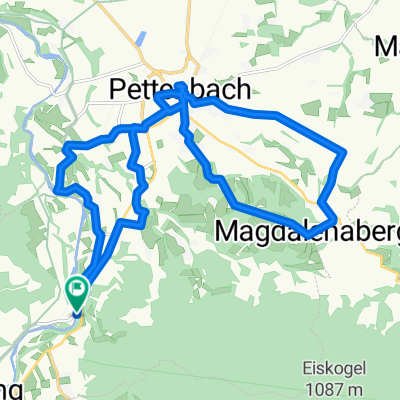
Pettenbach - Ried im Traunkreis (Ortszentren, Umgehung von Hauptverkehrsstraßen)
A cycling route starting in Scharnstein, Upper Austria, Austria.
Overview
About this route
Zuerst ist der Welser Straße nach Norden aus dem Ortszentrum hinaus zu folgen, vor der Eisenbahnstrecke hält man sich aber rechts, folgt der Wilflingstraße auf fast 2 km bis zur nächsten Siedlung, wo man der 90-Grad Linkskurve folgt, die die Straße beschreibt, wonach es für weitere 1,5 km im Straßenverlauf nach Norden geht, bis man gegenüber eines Hofes nach rechts auf die Stampf abbiegt. Dieser Weg ist zunächst asphaltiert, nach einer Hauszufahrt wird er aber unbefestigt und führt über den Aiterbach, führt nach weiteren 500 Metern wieder auf eine befestigte Straße, auf die man nach links abbiegt. Nun fährt man zwischen Feldern hindurch etwas über 1 km, biegt dann an einer Gabelung nach rechts ab, fährt bis zu einem Hof, nach dem man sich links hält. Der folgende Weg führt durch ein kleines Tal, dann wieder bergauf. Von nun an kann man dem Straßenverlauf folgen (Schachadorf), bis man auf die Pyhrnpass Straße (B138) stößt, auf welche nach links abzubiegen ist. Nach wenigen hundert Metern hält man sich wieder rechts Richtung Autobahn, überquert selbige und gelangt nach Durchquerung des folgenden Tales nach Ried im Traunkreis, wo sich das Gemeindeamt nach der langgezogenen Rechtskurve linkerseits befindet.
Dauer: 30-35 Minuten- -:--
- Duration
- 10.9 km
- Distance
- 106 m
- Ascent
- 129 m
- Descent
- ---
- Avg. speed
- ---
- Max. altitude
Route quality
Waytypes & surfaces along the route
Waytypes
Quiet road
7.3 km
(67 %)
Road
0.5 km
(5 %)
Surfaces
Paved
5 km
(46 %)
Unpaved
0.5 km
(5 %)
Paved (undefined)
3 km
(28 %)
Asphalt
2 km
(18 %)
Continue with Bikemap
Use, edit, or download this cycling route
You would like to ride Pettenbach - Ried im Traunkreis (Ortszentren, Umgehung von Hauptverkehrsstraßen) or customize it for your own trip? Here is what you can do with this Bikemap route:
Free features
- Save this route as favorite or in collections
- Copy & plan your own version of this route
- Sync your route with Garmin or Wahoo
Premium features
Free trial for 3 days, or one-time payment. More about Bikemap Premium.
- Navigate this route on iOS & Android
- Export a GPX / KML file of this route
- Create your custom printout (try it for free)
- Download this route for offline navigation
Discover more Premium features.
Get Bikemap PremiumFrom our community
Other popular routes starting in Scharnstein
 Hochsalm
- Distance
- 6.6 km
- Ascent
- 715 m
- Descent
- 15 m
- Location
- Scharnstein, Upper Austria, Austria
 laudachsee
- Distance
- 38.6 km
- Ascent
- 1,543 m
- Descent
- 1,544 m
- Location
- Scharnstein, Upper Austria, Austria
 Viechtwang-Grünau_2
- Distance
- 18.3 km
- Ascent
- 149 m
- Descent
- 146 m
- Location
- Scharnstein, Upper Austria, Austria
 von Scharnstein ins Almtal
- Distance
- 58.5 km
- Ascent
- 347 m
- Descent
- 353 m
- Location
- Scharnstein, Upper Austria, Austria
 Pettenbach
- Distance
- 21.4 km
- Ascent
- 281 m
- Descent
- 281 m
- Location
- Scharnstein, Upper Austria, Austria
 OBK Schobermühle (Hendl) Scharnstein
- Distance
- 4.2 km
- Ascent
- 93 m
- Descent
- 25 m
- Location
- Scharnstein, Upper Austria, Austria
 Rundfahrt über Feichtenberg
- Distance
- 29 km
- Ascent
- 396 m
- Descent
- 393 m
- Location
- Scharnstein, Upper Austria, Austria
 Mühldorf nach Grünau im Altal
- Distance
- 20.7 km
- Ascent
- 266 m
- Descent
- 211 m
- Location
- Scharnstein, Upper Austria, Austria
Open it in the app