

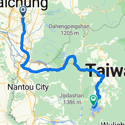
一江橋-赤崁頂
A cycling route starting in Taichung, Taiwan, Taiwan.
Overview
About this route
有點硬 要備果凍 食物.
- 1 h 18 min
- Duration
- 15 km
- Distance
- 739 m
- Ascent
- 138 m
- Descent
- 11.6 km/h
- Avg. speed
- ---
- Max. altitude

Route quality
Waytypes & surfaces along the route
Waytypes
Busy road
14.9 km
(99 %)
Road
0.1 km
(<1 %)
Surfaces
Paved
0 km
(<1 %)
Asphalt
0 km
(<1 %)
Undefined
15 km
(100 %)
Continue with Bikemap
Use, edit, or download this cycling route
You would like to ride 一江橋-赤崁頂 or customize it for your own trip? Here is what you can do with this Bikemap route:
Free features
- Save this route as favorite or in collections
- Copy & plan your own version of this route
- Sync your route with Garmin or Wahoo
Premium features
Free trial for 3 days, or one-time payment. More about Bikemap Premium.
- Navigate this route on iOS & Android
- Export a GPX / KML file of this route
- Create your custom printout (try it for free)
- Download this route for offline navigation
Discover more Premium features.
Get Bikemap PremiumFrom our community
Other popular routes starting in Taichung
 環島路線-海線
- Distance
- 1,073 km
- Ascent
- 1,095 m
- Descent
- 1,095 m
- Location
- Taichung, Taiwan, Taiwan
 牛角坑大石壁
- Distance
- 12 km
- Ascent
- 465 m
- Descent
- 463 m
- Location
- Taichung, Taiwan, Taiwan
 136
136- Distance
- 19.3 km
- Ascent
- 754 m
- Descent
- 297 m
- Location
- Taichung, Taiwan, Taiwan
 太平_老鼠崎
- Distance
- 8.4 km
- Ascent
- 473 m
- Descent
- 457 m
- Location
- Taichung, Taiwan, Taiwan
 日月潭 平易近人 路線
- Distance
- 149.1 km
- Ascent
- 1,064 m
- Descent
- 1,062 m
- Location
- Taichung, Taiwan, Taiwan
 華盛頓中學_四方太子宮
- Distance
- 5.7 km
- Ascent
- 345 m
- Descent
- 151 m
- Location
- Taichung, Taiwan, Taiwan
 台中-日月潭
- Distance
- 72.4 km
- Ascent
- 1,089 m
- Descent
- 559 m
- Location
- Taichung, Taiwan, Taiwan
 傳說中的136
- Distance
- 19.2 km
- Ascent
- 997 m
- Descent
- 961 m
- Location
- Taichung, Taiwan, Taiwan
Open it in the app