

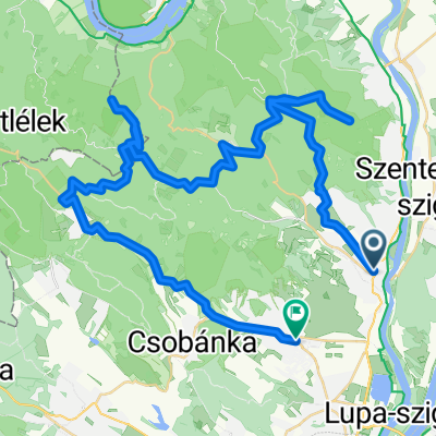
Lom-hegy
A cycling route starting in Szentendre, Pest County, Hungary.
Overview
About this route
Kellemes félnapos hegymászás. 5-6 km, helyenként meredek, végig aszfaltozott út, de az útfelület töredezett. 30-40 perc alatt kényelmesen megmászható MTB-kal.
A nice semi-day mountain climb. 5-6 km, sometimes steep. Paved all the way, but the tarmac is broken up. 30-40 convenient minutes to the top by MTB.- -:--
- Duration
- 13.9 km
- Distance
- 439 m
- Ascent
- 440 m
- Descent
- ---
- Avg. speed
- ---
- Max. altitude

Route quality
Waytypes & surfaces along the route
Waytypes
Road
9.1 km
(66 %)
Track
4.4 km
(32 %)
Surfaces
Paved
9.1 km
(66 %)
Unpaved
4.8 km
(34 %)
Asphalt
9.1 km
(66 %)
Gravel
3.7 km
(27 %)
Continue with Bikemap
Use, edit, or download this cycling route
You would like to ride Lom-hegy or customize it for your own trip? Here is what you can do with this Bikemap route:
Free features
- Save this route as favorite or in collections
- Copy & plan your own version of this route
- Sync your route with Garmin or Wahoo
Premium features
Free trial for 3 days, or one-time payment. More about Bikemap Premium.
- Navigate this route on iOS & Android
- Export a GPX / KML file of this route
- Create your custom printout (try it for free)
- Download this route for offline navigation
Discover more Premium features.
Get Bikemap PremiumFrom our community
Other popular routes starting in Szentendre
 Szentendre - Pilisszentlászló
- Distance
- 14.9 km
- Ascent
- 259 m
- Descent
- 259 m
- Location
- Szentendre, Pest County, Hungary
 Szentendre - Csobánka - Budakalász
- Distance
- 37.1 km
- Ascent
- 351 m
- Descent
- 364 m
- Location
- Szentendre, Pest County, Hungary
 pap-rét melegítő
- Distance
- 18.6 km
- Ascent
- 394 m
- Descent
- 390 m
- Location
- Szentendre, Pest County, Hungary
 Vörös-kő kör
- Distance
- 17.4 km
- Ascent
- 595 m
- Descent
- 595 m
- Location
- Szentendre, Pest County, Hungary
 Zebegényi rétes nóta
- Distance
- 127.2 km
- Ascent
- 152 m
- Descent
- 152 m
- Location
- Szentendre, Pest County, Hungary
 Vércse próbanap
- Distance
- 81.8 km
- Ascent
- 993 m
- Descent
- 877 m
- Location
- Szentendre, Pest County, Hungary
 szentendere-pilisszentlászló-visegrád-szentendre
- Distance
- 45.3 km
- Ascent
- 803 m
- Descent
- 795 m
- Location
- Szentendre, Pest County, Hungary
 Szentendre - Pap-rét - Vörös-kő - Prédikálószék - Kakas-hegy - Pomáz
- Distance
- 58.2 km
- Ascent
- 1,181 m
- Descent
- 1,180 m
- Location
- Szentendre, Pest County, Hungary
Open it in the app