
Overview
About this route
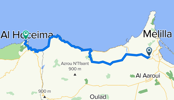
Côte Maroc : Etape 2 : Nador – Al Hoceïma
- -:--
- Duration
- 131.2 km
- Distance
- 1,241 m
- Ascent
- 1,291 m
- Descent
- ---
- Avg. speed
- ---
- Max. altitude

Part of
Côte Maroc
15 stages
Route quality
Waytypes & surfaces along the route
Waytypes
Busy road
61.7 km
(47 %)
Quiet road
56.3 km
(43 %)
Surfaces
Paved
87.6 km
(67 %)
Unpaved
16.8 km
(13 %)
Asphalt
87.4 km
(67 %)
Unpaved (undefined)
16.8 km
(13 %)
Continue with Bikemap
Use, edit, or download this cycling route
You would like to ride Côte Maroc 02 : Nador – Al Hoceïma or customize it for your own trip? Here is what you can do with this Bikemap route:
Free features
- Save this route as favorite or in collections
- Copy & plan your own version of this route
- Split it into stages to create a multi-day tour
- Sync your route with Garmin or Wahoo
Premium features
Free trial for 3 days, or one-time payment. More about Bikemap Premium.
- Navigate this route on iOS & Android
- Export a GPX / KML file of this route
- Create your custom printout (try it for free)
- Download this route for offline navigation
Discover more Premium features.
Get Bikemap PremiumFrom our community
Other popular routes starting in Nador
 Maroc2
- Distance
- 322.3 km
- Ascent
- 1,637 m
- Descent
- 1,250 m
- Location
- Nador, Oriental, Morocco
 Nador-Driouch
- Distance
- 66.5 km
- Ascent
- 671 m
- Descent
- 394 m
- Location
- Nador, Oriental, Morocco
 Bajada de Kol-la por pista hasta Palacio del Rey CLONED FROM ROUTE 538415
- Distance
- 15.2 km
- Ascent
- 82 m
- Descent
- 659 m
- Location
- Nador, Oriental, Morocco
 nador
nador- Distance
- 426.2 km
- Ascent
- 3,334 m
- Descent
- 1,869 m
- Location
- Nador, Oriental, Morocco
 Nador to surf to Tanger
- Distance
- 2,032.1 km
- Ascent
- 13,042 m
- Descent
- 13,052 m
- Location
- Nador, Oriental, Morocco
 mon parcours marocain
- Distance
- 3,421.2 km
- Ascent
- 2,234 m
- Descent
- 2,248 m
- Location
- Nador, Oriental, Morocco
 Paseo tranquilo
- Distance
- 11.8 km
- Ascent
- 328 m
- Descent
- 337 m
- Location
- Nador, Oriental, Morocco
 الطريق الجديد, الناظور to Unnamed Road, Beni Chiker
- Distance
- 28.4 km
- Ascent
- 560 m
- Descent
- 441 m
- Location
- Nador, Oriental, Morocco
Open it in the app