Tour de Croatia 2 Klauser See-Trieben
- 68 km
- 1,297 m
- 1,093 m
- Micheldorf in Oberösterreich, Upper Austria, Austria
A cycling route starting in Micheldorf in Oberösterreich, Upper Austria, Austria.
Overview
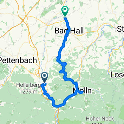
From the Oberschlierbach municipal office, turn left onto the Schiefer district road, leave it after a small forest where it makes a sharp left turn and continue straight ahead. After about 1.5 km downhill, you will go through a long left curve, after which the road splits. Here, keep left and then ride down the Kaiserleithn, which is quite steep in parts (200 meters of elevation over about 2 km), until you reach Käfergraben Hofern. Here, keep left, cross the stream, and after the next uphill, you will reach Stiftsstraße, keeping left there as well. Now it goes slightly uphill towards the Stift Schlierbach, near which there are shopping options and the municipal office. Duration: 15-25 minutes
created this 10 years ago
Route quality
Quiet road
4.7 km
(80 %)
Road
1.1 km
(19 %)
Access road
0.1 km
(1 %)
Paved
1.2 km
(20 %)
Asphalt
1.2 km
(20 %)
Undefined
4.7 km
(80 %)
Continue with Bikemap
You would like to ride Oberschlierbach - Schlierbach (Ortszentren, Umgehung von Hauptverkehrsstraßen) or customize it for your own trip? Here is what you can do with this Bikemap route:
Free trial for 3 days, or one-time payment. More about Bikemap Premium.
Discover more Premium features.
Get Bikemap PremiumFrom our community
Open it in the app