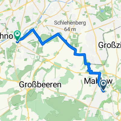
Zauchwitz pur
A cycling route starting in Lichtenrade, State of Berlin, Germany.
Overview
About this route
- -:--
- Duration
- 94.4 km
- Distance
- 224 m
- Ascent
- 225 m
- Descent
- ---
- Avg. speed
- 58 m
- Max. altitude
Route quality
Waytypes & surfaces along the route
Waytypes
Path
20.8 km
(22 %)
Quiet road
19.8 km
(21 %)
Surfaces
Paved
77.4 km
(82 %)
Unpaved
4.7 km
(5 %)
Asphalt
76.5 km
(81 %)
Ground
3.8 km
(4 %)
Continue with Bikemap
Use, edit, or download this cycling route
You would like to ride Zauchwitz pur or customize it for your own trip? Here is what you can do with this Bikemap route:
Free features
- Save this route as favorite or in collections
- Copy & plan your own version of this route
- Split it into stages to create a multi-day tour
- Sync your route with Garmin or Wahoo
Premium features
Free trial for 3 days, or one-time payment. More about Bikemap Premium.
- Navigate this route on iOS & Android
- Export a GPX / KML file of this route
- Create your custom printout (try it for free)
- Download this route for offline navigation
Discover more Premium features.
Get Bikemap PremiumFrom our community
Other popular routes starting in Lichtenrade
- flughafen ber 45km
- Distance
- 45.1 km
- Ascent
- 65 m
- Descent
- 65 m
- Location
- Lichtenrade, State of Berlin, Germany
- Lichtenrade-Kienitz
- Distance
- 31.1 km
- Ascent
- 42 m
- Descent
- 45 m
- Location
- Lichtenrade, State of Berlin, Germany
- Einführungsrunde 2009
- Distance
- 104.2 km
- Ascent
- 301 m
- Descent
- 281 m
- Location
- Lichtenrade, State of Berlin, Germany
- Meine kleine Südrunde
- Distance
- 17.1 km
- Ascent
- 38 m
- Descent
- 41 m
- Location
- Lichtenrade, State of Berlin, Germany
- Am Feld 1B, Blankenfelde-Mahlow nach Am Feld 1A, Blankenfelde-Mahlow
- Distance
- 34.8 km
- Ascent
- 224 m
- Descent
- 225 m
- Location
- Lichtenrade, State of Berlin, Germany
- Mahlow Waßmansdorf Rudow
- Distance
- 23.2 km
- Ascent
- 34 m
- Descent
- 32 m
- Location
- Lichtenrade, State of Berlin, Germany
- Vatertag 2020
- Distance
- 49.2 km
- Ascent
- 88 m
- Descent
- 90 m
- Location
- Lichtenrade, State of Berlin, Germany
- S Lichtenrade - Groß Schulzendorf - Lüdersdorf - Trebbin - Glau - Schenkenhorst - S Zehlendorf - S/U Bundesplatz
- Distance
- 88.9 km
- Ascent
- 186 m
- Descent
- 185 m
- Location
- Lichtenrade, State of Berlin, Germany
Open it in the app